Sturtevant Falls - Angeles Mountains - Member Hike
| Hike Name: | Sturtevant Falls - Angeles Mountains |
|---|---|
| Country: | United States |
| State: | California |
| Nearby Town: | Arcadia |
| Rating: |  |
| Directions: | From Southern California: 405 N. to Long Beach. Take the 605 N. (Exit 24) Merge onto 210 West Take the Santa Anita Avenue. exit and drive north through the mountains about 4.5 miles until you reach Chantry Flats and the parking lot. You must obtain a National Adventure Pass (pretty much just a parking pass) from the station at Chantry Flats. |
| Total Hike Distance: | 3.80 miles |
| Hike Difficulty: | Easy |
| Permit Required: | Yes |
| Hike Type: | In & Out, Backtrack Hike |
| Hike Starts/Ends: | Chantry Flats |
| Trails Used: | Gabrielino Trail to Sturdevant Falls and Back. From the lower parking lot, walk down the paved road into Big Santa Anita Canyon. You will cross a foot bridge, veer to the right. The trail will soon narrow. Follow this trail to the falls. |
| Backcountry Campsites: | No |
| Backcountry Water Sources: | Streams, Rivers |
| Management: | National Park Service |
| Contact Information: | Angeles National Forest Supervisor's Office 701 N. Santa Anita Ave. Arcadia, CA 91006 Jody Noiron, Forest Supervisor (626) 574-5200 FAX (626) 574-5233 CRS 1 800 735 2929 M-F 8:00 am - 4:30 pm |
| Best Season: | Spring, Fall |
| Users: | Hikers, Dogs, Horses |
| Road Conditions: | Secondary Paved Roads |
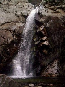
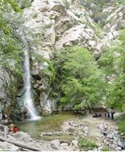
| Hike Summary: | http://tchester.org/sgm/trails/chantry_flat.html Elevation Gain/loss: 700' Trailhead: 2200' Sturdevant Falls: 2100' As you can see by the elevation, this hike starts at the high point and end at the low point. So you will be hiking uphill on the way back. The hike is easy with serveral payoffs and beautiful scenery. We went early in the season and there weren't many people on the trails, but I hear it can get quit packed at the falls during the summer. "Sturtevant Falls was named for canyon pioneer Wilbur M. Sturtevant, who carved out a trail in the 1890s and built his Sturtevant Camp trail resort two miles up canyon from the falls" (Dan's Hiking Page). Sturdevant falls is 50' of cascading water flowing into a beautiful jungle like environment. The area is forested and shaded. You don't have to worry about overheating on this hike nesteled under large oak and alder trees. There are several cabins nestled in the hills along the way. From what I understand, these cabins are owned, but the forest service prohibits permanent occupancy, so most people use them as vacation homes. People have to ride horses or walk to get to these cabins, as there are no roads leading back into the forest. There are several check dams along the way, built by the Los Angeles County Flood Control District and Forest Service in the 1960's, which detract a little from the remote, natural feel of the trails, but overall not enough to ruin any part of the journey. I would reccoment walking the extra 2 miles to Hoegees Camp ground, which is only another 2 miles up the trail. It is tucked away by the river under a dence camopy of trees. There are several tent camping spots, fire pits, and water by the river. |


One reply on “Sturtevant Falls - Angeles Mountains - Member Hike”
Is camping allowed here.