Red Box to Strawberry Spring, Strawberry Meadow - Angeles National Forest - Member Hike
| Hike Name: | Red Box to Strawberry Spring, Strawberry Meadow - Angeles National Forest |
|---|---|
| Country: | United States |
| State: | California |
| Nearby Town: | La Canada-Flintridge |
| Rating: |  |
| Directions: | Approx 14 miles from La Canada, off of Angeles Crest Highway. Park at Red Box Ranger station. |
| Total Hike Distance: | 9.00 miles |
| Hike Difficulty: | Moderate |
| Permit Required: | No |
| Hike Type: | In & Out, Backtrack Hike |
| Hike Starts/Ends: | Red Box |
| Trails Used: | Strawberry Peak Circuit Trail/ Upper Colby Trail |
| Backcountry Campsites: | No |
| Backcountry Water Sources: | Streams, Springs |
| Management: | U.S. Forest Service |
| Contact Information: | Angeles National Forest 701 N. Santa Anita Avenue Arcadia, CA 91006 626-574-1613 www.r5.fs.fed.us/angeles |
| Best Season: | Spring, Fall |
| Users: | Hikers, Bikers, Dogs, Horses |
| Road Conditions: | Primary Paved Roads |
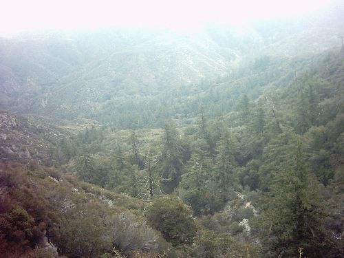
| Hike Summary: | #38 in John W Robinson's "Trails of the Angeles" A beautiful hike with exceptional variety. This hike begins at Angeles Crest Highway just across from Red Box Ranger Station. Older topos show the trailhead as a fire road however, it is no longer maintained as such. You climb the degraded fire road a little more than 1/2 mile, parrallel to ACH. The "road" ends as you turn North coming soon to a junction of ridges with paths worn in by climbers. Follow the sign marked "trail". About 1.3 Miles up trail you come to Lawlor saddle. The sign indicates ridge routes up Strawberry Peak and Mount Lawlor. You continue ahead towards Colby Ranch. The view below opens up as you approach Strawberry Spring, 1 mile from the saddle. The Spring runs most of the year. During the wetter months it runs across the trail. This is a nice shady spot to rest. Beyond the spring you begin to wind downward toward the Colby Ranch junction .5 miles. You will follw the trail left (S) into Strawberry meadows. You can follow this trail to the first and then second meadow before the trail begins to climb up and around to Josephine Saddle. Strawberry peaks' granite tower looms over the meadow. Relax here for a while, and return the way you came. You may also take one the alternative routes suggested by Robinson. Each of which would require a car shuttle, or long loop return. NOTE: Robinson also mentions a vaguely marked side trail SouthWest of the first meadow. The trail is marked on a large boulder by a red arrow. I have yet to find this trail. I intend on doing this hike a second time, as last time was very foggy. I will report further on the "secret" meadow. |


There are no comments yet.