Manker Flat to Baldy Notch, Devil's Backbone, Mt. San Antonio - Member Hike
| Hike Name: | Manker Flat to Baldy Notch, Devil's Backbone, Mt. San Antonio |
|---|---|
| Country: | United States |
| State: | California |
| Nearby Town: | Mt. Baldy Village |
| Rating: |  |
| Directions: | The upper end of Mt. Baldy road 15 Miles north of Claremont |
| Total Hike Distance: | 13.00 miles |
| Hike Difficulty: | Difficult |
| Permit Required: | No |
| Hike Type: | In & Out, Backtrack Hike |
| Hike Starts/Ends: | Manker Flat |
| Trails Used: | Devil's Backbone |
| Backcountry Campsites: | No |
| Backcountry Water Sources: | None, Streams, Springs, Snow |
| Management: | U.S. Forest Service |
| Contact Information: | Angeles National Forest 701 N. Santa Anita Avenue Arcadia, CA 91006 626-574-1613 www.r5.fs.fed.us/angeles |
| Best Season: | Spring, Summer, Fall |
| Users: | Hikers |
| Road Conditions: | Primary Paved Roads |
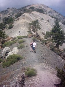
| Hike Summary: | Copy/Paste Coming #91 in John W. Robinson's "Trails Of the Angeles" This is a must do hike. Although the "Ski Hut" trail is the most desireable ascent of Mt. "Baldy", this is the most attainable for the average hiker (it moitivated me to plan a trip via the ski hut trail). It can also be softened by taking the ski lift to Baldy Notch. The trail head is located on a fire road just North of Manker campground. The road would be on your left, the road is divided by a median at this point. If you reach the ski lift parking lot, you have driven 1/2 mile too far (If you chose to shorten the trip by taking the ski lift then you would use thier lot). Walk around the gate and up the road. There are some private cabins to your left. San Antonoio falls soon come into view. You can view the falls from here or leave the road to get a closer look (unfortunately, none of the pictures I took of the falls turned out good enough to post). Once you have taken in the falls continue up the road at just over 1/4 mile past the falls the "Ski Hut" trail intersects on your left. That is the more advanced route, well worth the extra effort. I hope to be logging that hike here soon. he distance between the road and the "notch" is approx. 3 miles. It is a steady climb, passing under the ski lifts and switchbaking up the opposite slope. When you reach the notch |


There are no comments yet.