Hastings Peak Via Bailey Canyon Trail, Return Via Mt. Wilson Trail - Member Hike
| Hike Name: | Hastings Peak Via Bailey Canyon Trail, Return Via Mt. Wilson Trail |
|---|---|
| Country: | United States |
| State: | California |
| Nearby Town: | Sierra Madre |
| Rating: |  |
| Directions: | From the 210 Foothill Freeway Arcadia, exit Baldwin Avenue and go north (Straight). Baldwin Avenue ends at Carter st. Turn Left. Take Carter about 1/3mi. The Parking lot will be on your right. If you reach a dead-end, you just passed it. The park closes at dusk, so plan accordingly. Mount Wilson Trailhead (if you want to car shuttle). |
| Total Hike Distance: | 10.00 miles |
| Hike Difficulty: | Moderate to Difficult |
| Permit Required: | No |
| Hike Type: | Roundtrip, Loop Hike |
| Hike Starts/Ends: | Bailey Canyon Wilderness Park |
| Trails Used: | Bailey Canyon Trail, Hastings ridge trail, Lost Canyon Trail, Old Mt. Wilson Trail |
| Backcountry Campsites: | No |
| Backcountry Water Sources: | Streams |
| Management: | City Park Service |
| Contact Information: | City of Sierra Madre City Hall 232 W. Sierra Madre Blvd. Sierra Madre, CA 91024 T:626.355.7135 http://www.cityofsierramadre.com/index.php?mod=parks http://www.cityofsierramadre.com/index.php?pageNum_rsRelPages=0&totalRows_rsRelPages=6&mod=bailey_canyon |
| Best Season: | Winter, Spring, Fall |
| Users: | Hikers, Dogs |
| Road Conditions: | Primary Paved Roads |
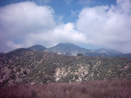
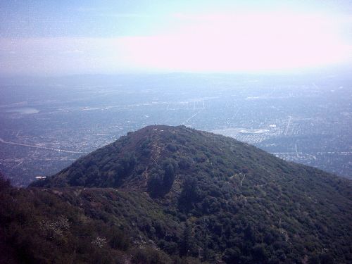
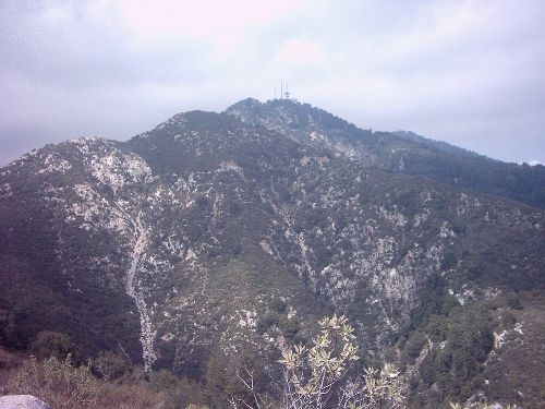
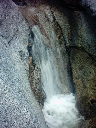
| Hike Summary: | This hike is amore interesting and strenuous variation of the Bailey Canyon to Jones Peak hike. Hastings Peak offers a better view, and about 1000’ higher elevation without adding too greatly to the effort. Furthermore, the return route is varied by following a rough path down to the Old Mount Wilson trail, just above first water. You get the urban views from Bailey canyon, Jones and Hastings peaks, as well as the shaded (for a fair portion) and quiet Little Santa Anita canyon. This trip includes a short walk on city streets (.8miles) . You can park a bike at the Mount Wilson trailhead and drive to Bailey Canyon Wilderness Park, or simply walk the short distance to your car. You start out in the parking area at Bailey Park. Follow a wood-chip path NW to a turnstile. You step out onto a paved road passing a debris dam. The pavement ends at a junction. The Live Oak nature trail is to your right, across a small bridge. Continue straight N, soon crossing a small stream. Just beyond the trail splits. To the left you can take a short side trek to visit the falls (about 1/2mile round trip) or continue to the right. You begin to switchback, climbing steadily. At about 1 mile you reach a bench where you can rest and look over the San Gabriel Valley. Continuing ahead, you snake around the canyon in a back and forth pattern. Only once or twice do you come to a ridge allowing an easterly view. There is little to no shade most of the way. At 3.3 Miles, you reach a split in the trail. A few yards left W, you come to the remnants of an old cabin. Not much left but, a good flat spot to sit. Straight ahead and down is a small shady streambed, also a good place to sit, with some insulation to the sounds of Freeways below. Heading Back up-trail, you meet a series of short, steep switchbacks. Once over these the trail resumes its steady zigzag pattern. There is some intermittent shade once up from the cabin site. At 3.2miles you reach Jones Saddle, located just behind the peak itself. The path to the peak is a steep and slightly loose. It is a thankfully short 1/10 of a mile. From the peak you can get a good view of the Valley and beyond. This is a good spot to take in the view but there is no shade. Return to the saddle and continue north to a fork. You’ll find a sign marking the ridge trail to Hastings Peak (left 1 mile). Take the ridge up. You’ll get some really good views of Mount Wilson/Harvard, as well as broad views of the Valley an L.A. basin. It’s pretty easy going compared to some of the steeper sections coming up the canyon. You’ll pass a lesser peak on the way up and descend a short distance. As you get closer to Hastings peak (4163’), you encounter a few steep spots but nothing too strenuous. The best thing about the approach is that you can see the peak nearly the whole way (there is a flagpole on top). Once on top sign the register and enjoy the expansive view. Return down the ridge and back to the junction. Now go left (north) and descend a slightly rough trail down into Lost Canyon (1 mile) and connect with the Mt. Wilson trail. It’s a bit rock but definitely passable, and maintained. You spill into Lost Canyon, and meet the trail just below the Helispot. You can head up-trail a couple hundred yards, or continue down-trail to First Water (see Sierra Madre to Orchard Camp hike description). Hang out at first water and head the rest of the way down to the trailhead just above Mira Monte Blvd in Sierra Madre. From here you can walk or bike back to your car at Bailey park. Walk west on Mira Monte, Right on Baldwin Ave, Left on Carter about ½ mile to the park. Some Interesting Links: http://home.earthlink.net/~kirkm2506/JonesPeak.html http://www.tchester.org/sgm/trails/bailey.html http://www.sierramadrenews.net/bailey.htm |


There are no comments yet.