BMT section 3 and 4 - Member Hike
| Hike Name: | BMT section 3 and 4 |
|---|---|
| Country: | United States |
| State: | Alabama |
| Nearby Town: | Blue Ridge |
| Rating: |  |
| Directions: | Take highway 76 north past Blue Ridge. Turn south on highway 60. Go through Morganton and continue south on highway 60 approximately 10 miles. There is a hiking sign at the top of the mountain at Wilcox Gap. A spacious parking area is available on the left. |
| Total Hike Distance: | 11.00 miles |
| Hike Difficulty: | Moderate to Difficult |
| Permit Required: | No |
| Hike Type: | One-Way, Shuttle Hike |
| Hike Starts: | Wilcox Gap |
| Hike Ends: | Tooni Gap |
| Trails Used: | Benton Mckaye section 3 and 4 |
| Backcountry Campsites: | No |
| Backcountry Water Sources: | Springs |
| Management: | U.S. Forest Service |
| Contact Information: | hattahoochee National Forest Toccoa Ranger District 6050 Appalachian Highway Blue Ridge, GA 30513 Phone: 706 632-3031 http://www.fs.fed.us/conf/ |
| Best Season: | Winter, Spring, Summer, Fall |
| Users: | Hikers |
| Road Conditions: | Primary Paved Roads |
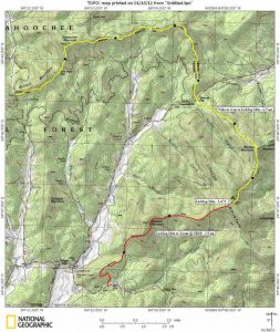
| Hike Summary: | January 21-22, 2012. We headed south at Wilcox Gap, start of section 4 of the BMT, at 10:15. Rained for 2 hours. Reached Payne Gap (3.2 miles) and ate lunch. Water source is 600 feet north. Continued on to Skeenah Gap (5.2 miles) reaching it around 1:00. Took another break before starting section 3 of the BMT. Trail climbs 1000 feet to Rhodes Mountain (1.5 miles). This is the most strenuous portion of section 3 if you're heading south. The BMT joins the Duncan Ridge Trail just below the summit of Rhodes Mountain. From there, it's about a half mile to the gap where we camped for the night (2.1 miles). There is a spring 300 feet to the east. A "W" sign points in the direction of the spring, but be sure to follow the blue blazes and the trail that leads to the water. It was wet so we didn't have a fire. We turned in early and got up at 8 the next morning. It was windy and foggy. After eating breakfast, we broke camp around 10 and ascended Lick Log Mountain (elevation 3472), the highest point on section 3. We continued on past Wallalah Mountain and stopped at an overlook to the south (4.3 miles). After resting, we pushed on to Tooni Gap (5.6 miles) and arrived at 12:45. We saw no one the entire time we were on the trail. If you like solitude, this might be the hike for you. |


There are no comments yet.