Virginia Creeper Trail - Member Hike
| Hike Name: | Virginia Creeper Trail |
|---|---|
| Country: | United States |
| State: | Virginia |
| Nearby Town: | Damascus |
| Rating: |  |
| Directions: | From Damascus go east on 58 up to Whitetop Station |
| Total Hike Distance: | 34.00 miles |
| Hike Difficulty: | Easy |
| Permit Required: | No |
| Hike Type: | One-Way, Shuttle Hike |
| Hike Starts: | Whitetop Station |
| Hike Ends: | Abingdon Virginia |
| Trails Used: | Virginia Creeper Trail |
| Backcountry Campsites: | Yes |
| Backcountry Water Sources: | Streams, Rivers |
| Management: | U.S. Forest Service |
| Contact Information: | http://www.vacreepertrail.com/ http://www.vacreepertrail.org/ |
| Best Season: | Spring, Summer, Fall |
| Users: | Hikers, Bikers, Horses |
| Road Conditions: | Maintained Gravel or Dirt Roads |
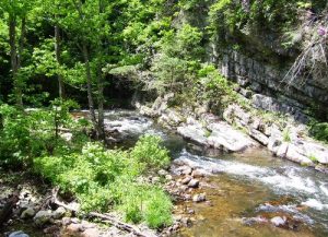
| Hike Summary: | This is primarily a bike trail. The first 16 or so miles starting from Whitetop to Damascus are pretty much downhill. Lot's of nice scenery. Primo trout waters along the way. The section from Damascus to Abingdon is fairly flat with very moderate elevation change. |


One reply on “Virginia Creeper Trail - Member Hike”
If you went to Trail Days 2008 while you were there, I want to hear about it.