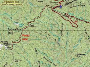
US highway 441; Newfound Gap - Clingman's Dome on Appalachian trail - Member Hike
| Hike Name: | US highway 441; Newfound Gap - Clingman's Dome on Appalachian trail |
|---|---|
| Country: | United States |
| State: | Tennessee |
| Nearby Town: | Gatlinburg, Tn and Cherokee, NC |
| Rating: |  |
| Directions: | Locate the parking area off of US 441 between Gatlinburg and Cherokee. Turn off Newfound Gap Road 0.1 mile south of Newfound Gap and follow the 7-mile-long Clingmans Dome Road to the large parking area at the end to park a car. Mileage to Clingmans Dome: from Cherokee—25 from Gatlinburg—23 |
| Total Hike Distance: | 8.00 miles |
| Hike Difficulty: | Easy to Moderate |
| Permit Required: | Yes |
| Hike Type: | One-Way, Shuttle Hike |
| Hike Starts: | Newfound Gap Parking area |
| Hike Ends: | Clingmans Dome |
| Trails Used: | Newfound Gap |
| Backcountry Campsites: | No |
| Backcountry Water Sources: | Streams, Springs |
| Management: | National Park Service |
| Contact Information: | By Mail Great Smoky Mountains National Park 107 Park Headquarters Road Gatlinburg, TN 37738 By Phone Visitor Information Recorded Message (865) 436-1200 By Fax 865-436-1220 http://www.nps.gov/grsm/planyourvisit/clingmansdome.htm and http://www.westcoastpeaks.com/Peaks/US/clingmansdome.html |
| Best Season: | Winter, Spring, Summer, Fall |
| Users: | Hikers |
| Road Conditions: | Primary Paved Roads, Secondary Paved Roads |
| Hike Summary: | Highlights: mountain views, high elevation spruce-fir forest At 6,643 feet, Clingmans Dome is the highest point in the Great Smoky Mountains National Park. It is the highest point in Tennessee, and the third highest mountain east of the Mississippi. Only Mt. Mitchell (6,684 feet) and Mt. Craig (6,647), both located in Mt. Mitchell State Park in western North Carolina, rise higher. The observation tower on the summit of Clingmans Dome offers spectacular 360° views of the Smokies and beyond for visitors willing to climb the steep half-mile walk to the tower at the top. On clear days views expand over a 100 miles. Unfortunately, air pollution often limits viewing distances to under 20 miles. Clouds, precipitation, and cold temperatures are common at Clingmans Dome. Temperatures at the dome can be 10 -20 degrees Fahrenheit cooler than in the surrounding lowlands. In fact, the cool, wet conditions on Clingmans Dome's summit make the spruce-fir forest that grows there a coniferous rainforest. Proper preparation is essential for a good visit. Dress in layers and be sure to bring a jacket, even in summer. Although Clingmans Dome is open year-round, the road leading to it is closed from December 1 through March 31, and whenever weather conditions require. It's seven miles to the end of Clingmans Dome Road and there are scenic pullouts with endless views of ridges and valleys along the way. The road ends in a large parking area from which a 0.5 mile trail leads to the summit. The trail is paved but steep, and leads to an observation tower on top. Besides the trail to the summit, there are several trails that start on Clingmans Dome Road and parking area. The Appalachian Trail (AT) crosses Clingmans Dome, marking the highest point along its journey from Georgia to Maine. The Forney Ridge Trail leads to Andrews Bald, a high-elevation grassy bald. |


There are no comments yet.