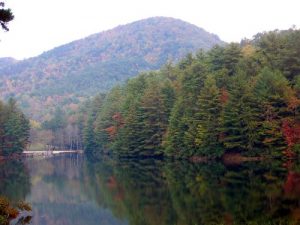
Unicoi Mountain Trail - Member Hike
| Hike Name: | Unicoi Mountain Trail |
|---|---|
| Country: | United States |
| State: | Tennessee |
| Nearby Town: | Benton |
| Rating: |  |
| Directions: | Directions: From Etowah, travel east on Mecca Pike (Highway. 310) for 13.8 miles to the intersection of Highway. 68 in Tellico Plains. Turn right and travel Highway 68 south 16.8 miles to the junction of the trail on the right above gated roads FDR #2135 and FDR #2135A. The trailhead is located on top of a hill and is not easy to see from the road. |
| Total Hike Distance: | 6.00 miles |
| Hike Difficulty: | Easy |
| Permit Required: | No |
| Hike Type: | In & Out, Backtrack Hike |
| Hike Starts/Ends: | FDR #2135 and FDR #2135A |
| Trails Used: | FDR #2135 and FDR #2135A, John Muir Trail #152 and close to Coker Creek Trail #183 |
| Backcountry Campsites: | No |
| Backcountry Water Sources: | Streams, Springs |
| Management: | None |
| Contact Information: | For more information contact: Ocoee Ranger District Route 1, Box 348 D Benton, TN 37307 (423) 338-5201 Hiwassee Ranger District Drawer D Etowah, TN 37331 (423) 263-5486 Tellico Ranger District 250 Ranger Station Road Tellico Plains, TN 37385-9371 (423) 253-2520 Chilhowee Rec. Area (USFS) Route 1, Box 348 D (Hwy 64) Benton, TN 37307 (423) 338-5201 |
| Best Season: | Winter, Spring, Summer, Fall |
| Users: | Hikers |
| Road Conditions: | |
| Hike Summary: | Covering 6 miles and rated easy his trail leads you over ridges, through hollows, pine woods. and near streams. It connects to the John Muir Trail #152 and close to Coker Creek Trail #183. Dispersed camping is available a short distance from the Junction of trails #83 and #152. Directions: From Etowah, travel east on Mecca Pike (Highway. 310) for 13.8 miles to the intersection of Highway. 68 in Tellico Plains. Turn right and travel Highway 68 south 16.8 miles to the junction of the trail on the right above gated roads FDR #2135 and FDR #2135A. The trailhead is located on top of a hill and is not easy to see from the road. |


There are no comments yet.