Sid's Falls - Member Hike
| Hike Name: | Sid's Falls |
|---|---|
| Country: | United States |
| State: | South Carolina |
| Nearby Town: | Westminster |
| Rating: |  |
| Directions: | From Westminster, drive west on US 76 for 13.3 miles and turn left at the Long Creek Fire Station onto Damascus Church Road. Drive 0.9 mile and turn right onto Battle Creek Road. Drive 3.8 miles to FS 2616 on the right. Park in front of the gate. (Damascus Church is appro .15 miles on the left past FS 2616) |
| Total Hike Distance: | 3.00 miles |
| Hike Difficulty: | Easy to Moderate |
| Permit Required: | No |
| Hike Type: | In & Out, Backtrack Hike |
| Hike Starts/Ends: | FS 2616 |
| Trails Used: | FS 2616 and Bernie's Trail to Sid's Falls |
| Backcountry Campsites: | No |
| Backcountry Water Sources: | Streams |
| Management: | U.S. Forest Service |
| Contact Information: | Sumter National Forest, Andrew Pickens Ranger District, 112 Andrew Pickens Circle, Mountain Rest, SC, 29664. Telephone: 864-638-9568 |
| Best Season: | Spring, Summer, Fall |
| Users: | Hikers |
| Road Conditions: | Primary Paved Roads |
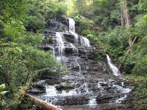
| Hike Summary: | Walk around the gate and follow FS 2616 for approx 1.25 miles. FS 2616 is a wide, grassy road that goes through, or around, three wildlife clearings before ending at a fourth clearing. At the far end of this fourth clearing, you will notice a faint trail. At the time of my hike, there was orange taping hanging beside the spot the trail goes into the pine forest. Once in the woods, it is easy to follow the trail even without the assistance of orange tape. (At spots, it looked like drunken sailors had been hanging orange tape.) The sound of the Shoulder Bone Branch and the waterfall will be in the gorge to your right. The trail takes you past the waterfall before cutting around and down to the falls. The last couple hundred yards is fairly steep but not too difficult to negotiate. |
Recommended

 Trail Map For This Area
Trip Reports
There are no Trip Reports yet.
There are no comments yet.