Savannah and Ogeechee Canal - Member Hike
| Hike Name: | Savannah and Ogeechee Canal |
|---|---|
| Country: | United States |
| State: | Georgia |
| Nearby Town: | Savannah and Tybee Island, Ga |
| Rating: |  |
| Directions: | This level walk follows the 1820's era Savannah and Ogeechee Canal from Ft. Argyle Road to the Ogeechee River. Located 2.5 miles west on Fort Argyle Road (204) from I-95 Exit 16/94. |
| Total Hike Distance: | 4.55 miles |
| Hike Difficulty: | Easy |
| Permit Required: | No |
| Hike Type: | Roundtrip, Loop Hike |
| Hike Starts/Ends: | Ft. Argyle Road |
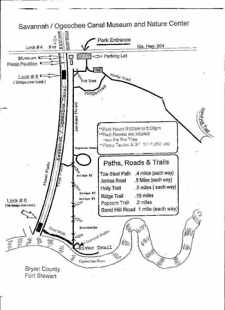
| Trails Used: | Heel Path, Tow Path (.4 mi each way), River Walk, River Trail, Jenkes Rd (.5 Mi) , Popcorn Trail (.2 mi), Ridge Trail (.5 mi), Holly Trail (.5 mi), and Sand Hill Rd (1 mi) |
| Backcountry Campsites: | No |
| Backcountry Water Sources: | None |
| Management: | State Park Service |
| Contact Information: | http://georgiatrails.com/trails/socanal.html http://www.sherpaguides.com/georgia/coast/northern_coast/near_savannah.html For more information: Savannah-Ogeechee Canal Society 681 Fort Argyle Road Savannah, GA 31419-9239. Email: socm@csam.net Phone (912) 748-8068. |
| Best Season: | Winter, Spring, Summer, Fall |
| Users: | Hikers, Bikers, Dogs |
| Road Conditions: | Primary Paved Roads, Secondary Paved Roads, Maintained Gravel or Dirt Roads |
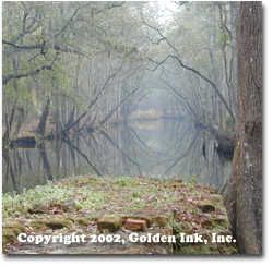
| Hike Summary: | Before trains and automobiles America moved on its rivers; when rivers did not go where transportation was needed canals were built. Although the Savannah and Ogeechee did not rival other canals in length or in amount of goods transported, it was an important route for the coastal plantations to get their crops to market. Rice, corn, naval stores, and lumber were all common products shipped along the Savannah and Ogeechee Canal. Most planters selected this canal for an economic reason: They could get their goods to market more quickly. Also, the canal was somewhat safer than trying to navigate the coastal islands and Savannah River. This level walk follows the 1820's era Savannah and Ogeechee Canal from Ft. Argyle Road to the Ogeechee River. Wide paths and photographic opportunities abound. Trail: Several 1-mile and shorter nature trails are found near the Savannah-Ogeechee Canal and Ogeechee River. Several trails take you through the lowland hardwood swamp. The 0.4-mile Heel Path, which follows the canal to the Ogeechee River, is accessed by crossing Lock #5 located by the museum and picnic pavilion. The Tow Path is on the eastern side, and is also a 0.4-mile walk to the river and Lock #6. On the grounds just west of the canal, U.S. Gen. William T. Sherman's army encamped. They crossed the canal and followed Jenckes Road. This 0.5-mile road is now a nature trail that leads to the Ogeechee River, crossing bridges and boardwalks. The easternmost route over the Ogeechee, Dillon Bridge, was located here. Confederates burned it to delay Sherman, but Union engineers quickly repaired it and marched on to Fort McAllister, where they overran the Confederate fort on December 13 before the evacuation and fall of Savannah on December 21. The 0.15-mile Ridge Trail leads off of Jenckes Road to the Holly Trail, which connects to an old logging road for access to the river dune community. The Popcorn Trail is a 0.2-mile loop off of Jenckes Road. |
Recommended


Trip Reports
| Date | Rating | Duration | Hiker | |
|---|---|---|---|---|

|
January 7, 2007 |  |
1 hour, 30 minutes | Tree Top Flyer |

|
December 15, 2006 |  |
4 hours | Tree Top Flyer |
There are no comments yet.