San Gabriel Wilderness - Copper Canyon - Member Hike
| Hike Name: | San Gabriel Wilderness - Copper Canyon |
|---|---|
| Country: | United States |
| State: | California |
| Nearby Town: | Pasadena |
| Rating: |  |
| Directions: | From the 210 Freeway, drive north on the Angeles Crest Highway into the San Gabriel Mountains. The campground entrance is on the left after thirty-four miles at mile-marker 58.25. The trailhead is located in Buckhorn Campground near the lowest point in the facility. Follow signs to the Buchhart Trail. Note: If you see the Snowcrest Ski Area you have gone to far. |
| Total Hike Distance: | 3.40 miles |
| Hike Difficulty: | Moderate |
| Permit Required: | No |
| Hike Type: | In & Out, Backtrack Hike |
| Hike Starts/Ends: | Buckhorn Campground |
| Trails Used: | Burkhart Trail, Pacific Crest Trail |
| Backcountry Campsites: | Yes |
| Backcountry Water Sources: | Streams |
| Management: | U.S. Forest Service |
| Contact Information: | Angeles National Forest 701 N. Santa Anita Avenue Arcadia, CA 91006 626-574-1613 www.r5.fs.fed.us/angeles |
| Best Season: | Spring, Summer, Fall |
| Users: | Hikers, Dogs, Horses |
| Road Conditions: | Primary Paved Roads, Secondary Paved Roads |
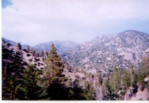
| Hike Summary: | The hike to Copper Canyon via Buckhorn Campground is on the Buckhart Trail which makes a moderate decent through a dry pine forest to Copper Creek and the Pacific Crest Trail. Here you have the option of returning to the campground, relaxing near the stream, or continuing on the Buckhart Trail for a short distance to a ridge with excellent views toward Burkhart Saddle. There is also a nice campsite near the intersection of the Burkhart Trail and the PCT. |


There are no comments yet.