Ramsey Cascades - Member Hike
| Hike Name: | Ramsey Cascades |
|---|---|
| Country: | United States |
| State: | Tennessee |
| Nearby Town: | Knoxville, Gatlinburg, Asheville |
| Rating: |  |
| Directions: | Access Trail: Ramsey Cascades Trail (Tennessee) Trailhead: Drive six miles east of Gatlinburg on Highway 321 and turn at the Greenbrier entrance to the park. Follow the signs 4.7 miles to the trailhead. |
| Total Hike Distance: | 8.00 miles |
| Hike Difficulty: | Moderate to Difficult |
| Permit Required: | No |
| Hike Type: | Roundtrip, Loop Hike |
| Hike Starts/Ends: | Greenbrier entrance to the park. Follow the signs 4.7 miles to the trailhead. |
| Trails Used: | Ramsey Cascades |
| Backcountry Campsites: | No |
| Backcountry Water Sources: | Streams, Rivers, Springs, Snow |
| Management: | National Park Service |
| Contact Information: | http://www.nps.gov/grsm/planyourvisit/waterfalls.htm |
| Best Season: | Spring, Summer, Fall |
| Users: | Hikers |
| Road Conditions: | Primary Paved Roads, Secondary Paved Roads |
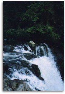
| Hike Summary: | Ramsey Cascades is the tallest waterfall in the park and one of the most spectacular. Water drops 100 feet over rock outcroppings and collects in a small pool where numerous well-camouflaged salamanders can be found. The trail to the waterfall gains over 2,000' in elevation over its 4 mile course and the 8-mile roundtrip hike is considered strenuous in difficulty. It follows rushing rivers and streams for much of its length. The last 2 miles pass through old-growth cove hardwood forest with large tuliptrees, basswoods, silverbells, and yellow birches. Do not attempt to climb to the top of the falls. Several people have been killed trying to do so. Access Trail: Ramsey Cascades Trail (Tennessee) Trailhead: Drive six miles east of Gatlinburg on Highway 321 and turn at the Greenbrier entrance to the park. Follow the signs 4.7 miles to the trailhead. |


There are no comments yet.