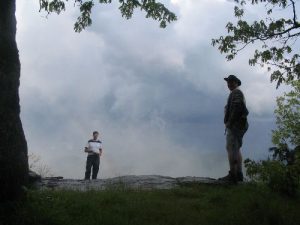
Preaching Rock - Member Hike
| Hike Name: | Preaching Rock |
|---|---|
| Country: | United States |
| State: | Georgia |
| Nearby Town: | Suches |
| Rating: |  |
| Directions: | From Dahlonega follow GA 60 north and park at the Woody Gap parking area. |
| Total Hike Distance: | 3.00 miles |
| Hike Difficulty: | Moderate to Difficult |
| Permit Required: | No |
| Hike Type: | In & Out, Backtrack Hike |
| Hike Starts/Ends: | GA 60 |
| Trails Used: | Appalachian Trail |
| Backcountry Campsites: | Yes |
| Backcountry Water Sources: | Springs |
| Management: | U.S. Forest Service |
| Contact Information: | Chattahoochee National Forest Blue Ridge District 1881 Highway 515 P.O. Box 9 Blairsville, GA 30512 Phone: 706 745-6928 Fax: 706 745-7494 Office hours: Mon. - Friday, 8:00 - 4:30 |
| Best Season: | Winter, Spring, Summer, Fall |
| Users: | Hikers, Dogs |
| Road Conditions: | Primary Paved Roads, Secondary Paved Roads |
| Hike Summary: | The Chattahoochee National Forest is one of two National Forests in the State of Georgia, and it takes its name from the Chattahoochee River whose headwaters begin in the North Georgia mountains. The River and the area were given the name by the English settlers who heard it from the Indians that once lived here. The Chattahoochee National Forest was created when the Forest Service purchased 31,000 acres in Fannin, Gilmer, Lumpkin and Union Counties from the Gennett family in 1911 for $7.00 per acre. In the beginning, the Chattahoochee was part of the Nantahala and Cherokee National Forests in North Carolina and Tennessee, but eventually the Forest Service made additional land purchases and expanded the Chattahoochee to its current size of nearly 750,000 acres. The Blood Mountain Wilderness area received its designation in 1991, and it is a sub-section of the Chattahoochee National Forest. The wilderness area is bordered to the northwest by Georgia Highway 60 and the Blue Ridge mountain range, and to the northeast by Georgia Highway 19/129 and Neels Gap. Major trails in this area include the Appalachian Trail, Freeman Trail, the Dockery Lake/Miller Gap Trail, the Coosa Backcountry Trail, the Duncan Ridge Trail, The Bare Hair Trail, and the Slaughter Creek Trail. The hike to Preaching Rock at 3,737 feet (or Big Cedar Mountain as it is sometimes called) is a short and moderate hike along the Appalachian Trail with an ascent that starts gradually from GA 60, then rises steeply to Preaching Rock. We day and overnight hiked this section and explored the ridge line around Preaching Rock which has excellent views to the southeast. |


One reply on “Preaching Rock - Member Hike”
The photos are of Granny Top, Preacher’s Rock was further South and Preacher’s Rock is on the AT. Granny Top is at the end of a short spur trail from the AT.