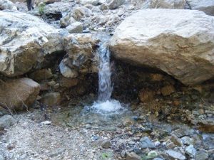
Millard Canyon Falls-Dawn Mine - Member Hike
| Hike Name: | Millard Canyon Falls-Dawn Mine |
|---|---|
| Country: | United States |
| State: | California |
| Nearby Town: | Azusa |
| Rating: |  |
| Directions: | Directions: Take the 210 Freeway west, exit at Fair Oaks Ave. and take Fair Oaks north toward the mountains. At Loma Alta Drive, turn left and proceed about ½ mile to Chaney Trail Drive. Turn right onto Chaney Trail Drive... (This is a small street, with trees blocking the sign, very easy to pass) and continue until you come to a sharp left & see the gate with a sign saying Sunset Ridge trail. Park here! there's not alot of parking so we need to get there early! You will need an Adventure Pass to park here. |
| Total Hike Distance: | 7.50 miles |
| Hike Difficulty: | Moderate to Difficult |
| Permit Required: | No |
| Hike Type: | In & Out, Backtrack Hike |
| Hike Starts/Ends: | Sunset Ridge trail |
| Trails Used: | Sunset Ridge trail to alittle past the falls which is below us & drop down into the canyon. A few miles up is the Dawn Mine which we'll explore. From here we'll head up the trail taking us north to Tom Sloan Saddle. |
| Backcountry Campsites: | Yes |
| Backcountry Water Sources: | Streams |
| Management: | State Park Service |
| Contact Information: | Angeles National Forest |
| Best Season: | Winter, Spring, Fall |
| Users: | Hikers |
| Road Conditions: | Primary Paved Roads |
| Hike Summary: | The trail has been washed out on the hillside past the mines so we'll have to hike up the creek & do some boulder hopping. |


There are no comments yet.