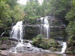
Long Creek Falls - Member Hike
| Hike Name: | Long Creek Falls |
|---|---|
| Country: | United States |
| State: | South Carolina |
| Nearby Town: | Westminster |
| Rating: |  |
| Directions: | From Westminster drive west on US 76 for 13.3 miles and turn left onto Damascus Church Road. Drive 0.8 mile and turn right onto Battle Creek Road. Drive 1.9 miles and turn right onto Turkey Ridge Road, a gravel road. Drive to the end of Turkey Ridge Road (approximately 3 miles). Park in the grassy clearing near FS 755 I. |
| Total Hike Distance: | 3.40 miles |
| Hike Difficulty: | Moderate |
| Permit Required: | No |
| Hike Type: | In & Out, Backtrack Hike |
| Hike Starts/Ends: | Turkey Ridge Road and FS 755 I |
| Trails Used: | FS 755 I and unnamed trail |
| Backcountry Campsites: | No |
| Backcountry Water Sources: | Streams, Rivers |
| Management: | U.S. Forest Service |
| Contact Information: | Sumter National Forest, Andrew Pickens Ranger District, 112 Andrew Pickens Circle, Mountain Rest, SC, 29664. Telephone: 864-638-9568 |
| Best Season: | Winter, Spring, Summer, Fall |
| Users: | Hikers |
| Road Conditions: | Primary Paved Roads, Maintained Gravel or Dirt Roads |
| Hike Summary: | On the right side of the parking lot, take FS 755 I. (A few yards down FS 755 I, there was a small white sign indicating LCF.) After about .1 miles, you will come to another small parking area, keep right. (At this point there is a sign which reads, "Long Creek Falls 1.6 mile.") After approx .5 miles, FS 755 I ends in a small parking area. Take the trail on the right side of the parking area. As you hike this trail, you can hear the Chattooga River off to the left. After .7 miles, you will clearly hear the falls and see a distinct, steep trail descending to the left. Except when slick from recent rains, this side trail is fairly easy to descend with mountain laurel and other undergrowth offering handholds. After approximately .1 miles, you will arrive at the Chattooga River. The base of the falls is to the right. |
Recommended
Trip Reports
There are no Trip Reports yet.


 Trail Map For This Area
There are no comments yet.