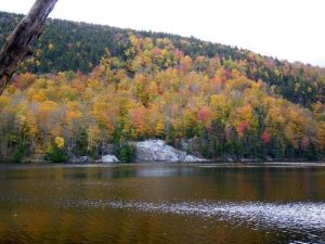
Little Rock Pond - Member Hike
| Hike Name: | Little Rock Pond |
|---|---|
| Country: | United States |
| State: | Vermont |
| Nearby Town: | Danby |
| Rating: |  |
| Directions: | From Route 7 in Danby – From Route 7, take Brooklyn Road (Forest Road 10) east. At .8 mi. you will enter the White Rocks National Recreation Area. [At .9 mi. there is a small parking area where you can access other trails.] Cross the Big Branch river and continue on. At 2.6 mi. you’ll reach the Big Branch Overlook on your right, which has an outhouse, a few picnic tables and a grill. At 2.9 mi. you’ll pass an oldtime apple orchard that survives to offer food for wildlife just before the paved road turns to dirt at 3.0 mi. Shortly at 3.2 mi. you’ve reached the trailhead parking lot that can accommodate over 20 vehicles. The trailhead is directly across the road; there is an outhouse as well. |
| Total Hike Distance: | 5.00 miles |
| Hike Difficulty: | Easy to Moderate |
| Permit Required: | No |
| Hike Type: | Roundtrip, Loop Hike |
| Hike Starts/Ends: | At the trailhead |
| Trails Used: | Little Rock Pond is a great example of a wilderness pond, and offers the chance for some remote fishing and swimming. This is a popular trail and you may encounter several Longtrailers as well as day hikers. If you’d like to camp (first-come/first-served, $5 use fee paid to a caretaker) there is the Lula Tye Shelter that is popular with Longtrailers (.3 mile south of the pond) and also a tent platform area at the pond itself. The “little rock” for which the pond is named is about 30 feet high and offers a nice open viewpoint from the west shoreline as well as a convenient place to sun, snack and rest. Starting from the parking lot, the easy to follow white-blazed trail runs alongside the Little Black Brook generally north in a very gradual rise through a mixed forest. The early stage is easy and dry, but eventually the path turns stony and wet and there are several areas that often have to be crossed on planking (puncheon). Stay on the trail and puncheon to minimize damage to the surrounding area. At one point, you must walk across a steel I-beam to cross the brook. Without fanfare, at about 1.75 miles the trail comes to a T at the Little Rock Pond. You can circle the pond in either direction. Going left takes you to the west shore and the “little rock” itself. Going right hugs the east shore, with a few spots where you can enter the pond for swimming. At the north end of the pond is the pond’s outlet, and the junction where you have the options to: a) continue on around the pond loop and return as you came to the trailhead and parking lot; b) take a longer route back to the trailhead and parking lot via the blue-blazed Green Mountain Trail (4.5 mi. to your starting trailhead; see the separate Green Mountain Trail description); c) continue north further up the trail along the Homer Stone Brook Trail. |
| Backcountry Campsites: | Yes |
| Backcountry Water Sources: | Streams, Lakes, Snow |
| Management: | None |
| Contact Information: | Unknown |
| Best Season: | Fall |
| Users: | Hikers, Dogs |
| Road Conditions: | Secondary Paved Roads |
| Hike Summary: | This is a straightforward loop trail that reaches and circles Little Rock Pond, but if you desire you can extend the hike in either of two major ways when you reach the north end of the pond. Both options are clearly marked on signposts at the north end of the pond. 1) You can take a longer return route back to the trailhead by picking up the Green Mountain Trail, which is about 4.5 miles back to the trailhead compared to the direct Little Rock Pond Trail loop return of about 2 mi., and offers very different hiking including a viewpoint offering a hawk’s eye view of Little Rock Pond. See the separate description of the Green Mountain Trail. 2) You can continue north on the AT/LT when you reach the north end of the pond and then doubleback at any point. |


There are no comments yet.