Indian Cave State Park - Member Hike
| Hike Name: | Indian Cave State Park |
|---|---|
| Country: | United States |
| State: | Nebraska |
| Nearby Town: | Brownsville |
| Rating: |  |
| Directions: | From Lincoln: East on Hwy 2 to Nebraska City, South on Hwy 75 to Auburn, East on Hwy 136 (9 miles), South on Hwy 67 (9 miles), East on 64E (5 miles). |
| Total Hike Distance: | 1.50 miles |
| Hike Difficulty: | Moderate |
| Permit Required: | No |
| Hike Type: | In & Out, Backtrack Hike |
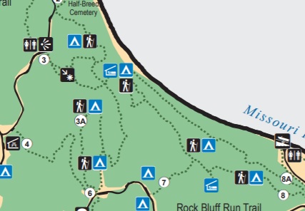
| Hike Starts/Ends: | Trailhead 3 |
| Trails Used: | Trailhead 3 |
| Backcountry Campsites: | Yes |
| Backcountry Water Sources: | Streams, Rivers |
| Management: | State Park Service |
| Contact Information: | Indian Cave State Park 65296 720 Road Shubert, NE 68437-9801 Phone: (402) 883-2575 |
| Best Season: | Winter, Spring, Summer, Fall |
| Users: | Hikers, Dogs, Horses |
| Road Conditions: | Primary Paved Roads, Secondary Paved Roads |
| Hike Summary: | Indian Cave State Park is located along the the Missouri River in southeastern Nebraska and has 22 miles of hiking and biking trails winding through the ~3,300 acres of park. This hike starts at Trailhead #3 where there are outstanding views from an overlook on the ridge line. From here, the trail descends ~300 feet and gradually through a lightly wooded prairie grass meadow and eventually levels off at the Missouri River. There are a collection of three Appalachian Trail type shelters above the river with outstanding views of the Missouri and it is worth the ~250' climb to see them. From here, you can continue continue on the trail for a much longer hiker or loop back to Trailhead #3 like we did. |


There are no comments yet.