Dillon Lake - Member Hike
| Hike Name: | Dillon Lake |
|---|---|
| Country: | United States |
| State: | Ohio |
| Nearby Town: | Nashport |
| Rating: |  |
| Directions: | From Downtown Zanesville: 1. Head west on Adair Ave/OH-146 toward Ashland Ave Continue to follow OH-146 12.0 mi 2. Turn left at Old Newark Rd 361 ft 3. Continue on Forest Ln Destination will be on the right |
| Total Hike Distance: | 1.00 miles |
| Hike Difficulty: | Moderate |
| Permit Required: | No |
| Hike Type: | In & Out, Backtrack Hike |
| Hike Starts/Ends: | Bridle Trail Staging Area Parking Lot |
| Trails Used: | Ruffed Grouse Nature Trail |
| Backcountry Campsites: | No |
| Backcountry Water Sources: | None |
| Management: | State Park Service |
| Contact Information: | Dillon State Park 5265 Dillon Hills Drive Nashport, OH 43830-9568 740-453-4377 Park Office 740-452-1083 Camp Office 866-644-6727 Cottage & camping reservations |
| Best Season: | Spring, Summer, Fall |
| Users: | Hikers, Bikers, Dogs |
| Road Conditions: | Primary Paved Roads, Secondary Paved Roads |
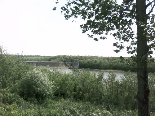
| Hike Summary: | Dillon State Park is located in in Muskingum County, a short distance from Zanesville, Ohio. The area possesses diverse and interesting natural features resulting from the unique properties of the Black Hand Sandstone. Sand, which eroded hundreds of millions of years ago from the mountains farther east, accumulated in a vast delta in the sea covering this region. The hard bedrock eroded to form sheer cliffs and supports a lush, hardwood forest in this area of East Central Ohio. In 1803, Moses Dillon purchased the land bordering the Licking River where the park is located. This industrious early American built and operated a local iron foundry, then creatd the village of Dillon Falls. Moses dammed the Licking River to provide water power for the community, and is probably most noted for his contributions toward the design and construction of the world-famous "Y" bridge in Zanesville. In 1961, construction on Dillon Reservoir was completed for flood control by the U.S. Army Corps of Engineers . Dillon State Park was dedicated a few years later in August 1968. The Ruffed Grouse Nature Trail is approximately 0.75-mile long and introduces the hiker to the varied habitats of the area. It starts at a parking area on the western side of the park, and this trail is a branch of the 6-mile long Licking Bend Trail which skirts the lakeshore. |


There are no comments yet.