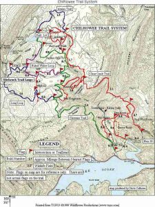
Clear Creek Trail - Member Hike
| Hike Name: | Clear Creek Trail |
|---|---|
| Country: | United States |
| State: | Tennessee |
| Nearby Town: | Etowah, Benton |
| Rating: |  |
| Directions: | Begins near Greasy Creek Campground off of Hwy 30. Trail ends at Chilhowee campground trailer dumping station |
| Total Hike Distance: | 5.40 miles |
| Hike Difficulty: | Moderate |
| Permit Required: | No |
| Hike Type: | One-Way, Shuttle Hike |
| Hike Starts: | Greasy Creek Campground |
| Hike Ends: | Chilhowee campground trailer dumping station |
| Trails Used: | Clear Creek Trail |
| Backcountry Campsites: | No |
| Backcountry Water Sources: | Streams, Rivers, Springs |
| Management: | National Park Service |
| Contact Information: | Tennessee Overhill Heritage Association PO Box 143 - Etowah, TN 37331 (423) 263-7232 · 1-877-510-5765 info@tennesseeoverhill.com |
| Best Season: | Winter, Spring, Summer, Fall |
| Users: | Hikers, Bikers, Dogs |
| Road Conditions: | Primary Paved Roads, Secondary Paved Roads, Maintained Gravel or Dirt Roads |
| Hike Summary: | Begins near Greasy Creek Campground off of Hwy 30. Trail ends at Chilhowee campground trailer dumping station. Another mountain bike system that a cousin of mine has completed several times. He says it's great for hikers as well. More information can be found here: http://images.google.com/imgres?imgurl=http://www.chattbike.com/images/maps/chilhmap.jpg&imgrefurl=http://www.chattbike.com/maps_cues/Mountain/chdifcue.htm&h=843&w=632&sz=205&hl=en&sig2=bwypn172W4dPOskUVso24A&start=1&tbnid=vF6Pvq9nApydGM:&tbnh=145&tbnw=109&ei=tt6qRd_-O5G4as-XjNUB&prev=/imagesqClearCreekTrailTnsvnum10hlenlrrlscom.microsoft:en-us:IE-SearchBoxrlz1I7GGLJ |


There are no comments yet.