Black Canyon of the Gunnison National Park - Warner Point - Member Hike
| Hike Name: | Black Canyon of the Gunnison National Park - Warner Point |
|---|---|
| Country: | United States |
| State: | Colorado |
| Nearby Town: | Montrose, CO |
| Rating: |  |
| Directions: | From Montrose, CO take US Hwy 50 east 8.2 miles to Hwy 347. Turn left and drive 7 miles to the Visitor Center. From the Visitor Center, follow the South Rim Road to its terminus about 7 miles later at High Point. This is the trail head to Warner Point. |
| Total Hike Distance: | 1.50 miles |
| Hike Difficulty: | Easy |
| Permit Required: | No |
| Hike Type: | In & Out, Backtrack Hike |
| Hike Starts/Ends: | High Point |
| Trails Used: | Warner Point Trail |
| Backcountry Campsites: | No |
| Backcountry Water Sources: | None |
| Management: | National Park Service |
| Contact Information: | Black Canyon of the Gunnison National Park 102 Elk Creek Gunnison, CO 81230 970-641-2337 www.nps.gov/blca |
| Best Season: | Spring, Summer, Fall |
| Users: | Hikers |
| Road Conditions: | Primary Paved Roads, Secondary Paved Roads |
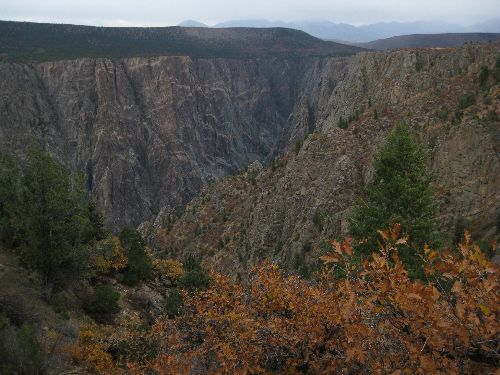
| Hike Summary: | Trail starts at the parking lot at High Point. It goes across the knob at High Point and descends into a saddle between ridges. Part of the downhill into the saddle is a series of stone steps. Most of the trail is through low gambel oak and juniper trees. After topping the second ridge, the trail descends a short way to the Warner Point overlook, from which are some great views of the canyon. Return by the same trail. |


There are no comments yet.