Big South Fork NRRA - Laurel Fork / John Muir - Member Hike
| Hike Name: | Big South Fork NRRA - Laurel Fork / John Muir |
|---|---|
| Country: | United States |
| State: | Tennessee |
| Nearby Town: | Oneida |
| Rating: |  |
| Directions: | From Cincinnati, Ohio, take I-75 south to Williamsburg, Kentucky. Take exit 11 and turn right on Kentucky 92. Travel approximately 19.9 miles and turn left on US 27 South. Travel another 13.6 miles and turn right on Industrial Lane. Go a short 0.7 miles and turn left on Tennessee 297 (Leatherwood Ford Road). Continue on 297 until you crossover the Big South Fork of the Cumberland River at Leatherwood Ford. Take the steep climb up out of the river gorge and look for Bandy Creek Road near the top. Go to the Visitor Center at the Bandy Creek Campground to check in. |
| Total Hike Distance: | 31.60 miles |
| Hike Difficulty: | Moderate to Difficult |
| Permit Required: | Yes |
| Hike Type: | One-Way, Shuttle Hike |
| Hike Starts: | Bandy Creek Campground |
| Hike Ends: | Leatherwood Ford |
| Trails Used: | West Entrance Bandy Creek Trail, Laurel Fork Creek Trail, John Muir Trail, Grand Gap Loop Trail |
| Backcountry Campsites: | No |
| Backcountry Water Sources: | Streams, Rivers |
| Management: | National Park Service |
| Contact Information: | Big South Fork NRRA 4564 Leatherwood Road Oneida, Tennessee 37841 (423) 286-7275 www.nps.gov/biso/ |
| Best Season: | Spring, Summer, Fall |
| Users: | Hikers |
| Road Conditions: | Primary Paved Roads, Secondary Paved Roads |
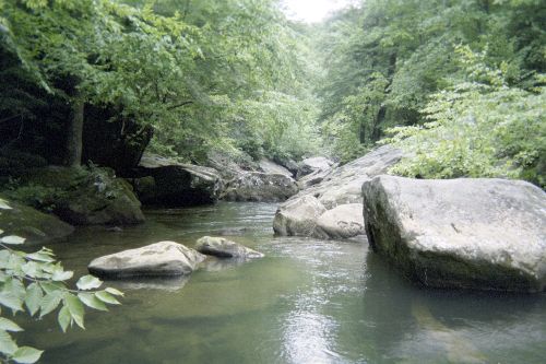
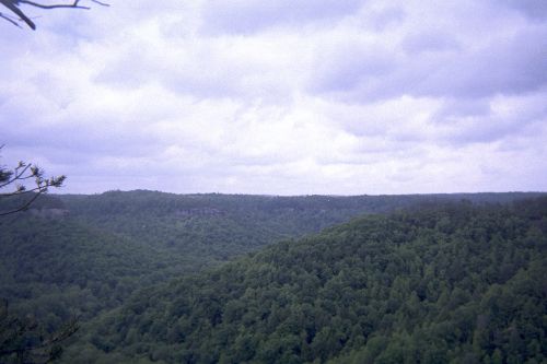
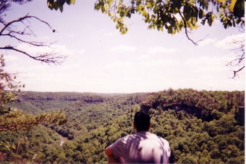
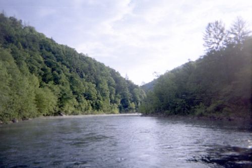
| Hike Summary: | The Big South Fork was established in 1974 as both a National Recreation Area and a National River. The area encompasses approximately 125,000 acres of the Cumberland Plateau, and protects the Big South Fork of the Cumberland River and its tributaries. There are miles and miles of hiking trails with an abundance of scenic gorges and sandstone overlooks. Trails range in length from short, single digit loop trails to longer, multi-day hikes through more rugged terrain. This particular hike begins at the Bandy Creek Campground, and travels west, then north, along the fairly level terrain of the West Entrance Bandy Creek Trail. After approximately 5 miles, the trail descends 300 feet to the Laurel Fork Creek Trail. Along this section of the trail, which parallels its namesake creek, there are numerous patches of hardwood forest that beckon the hiker to long respites along the banks of the free flowing creek. Any plans of a rigid schedule could easily be abandoned here. At the end of this 6.5 mile section, the trail meets up with a segment of the John Muir Trail, and rises approximately 550 feet in elevation. The next 10 miles or so parallel the Big South Fork of the Cumberland River from approximately 600 feet above. This section of the trail includes multiple sandstone overlooks, and a large population of pine trees (although a large portion of this population was damaged between 1998 and 2002 by the southern pine beetle). At the end of this section, the hiker can choose to take a quick cut-off that leads directly to the Angel Falls Overlook, or continue for another 7 miles along the ridge of the river gorge on the Grand Gap Loop Trail. Either way, near the junction of the two trails at the overlook, the trail narrows to a small footpath, which dips down to the Big South Fork. From there, the John Muir Trail continues along the banks of the river for approximately 2 miles to the parking lot/pickup site at Leatherwood Ford. |


There are no comments yet.