Big Frog Mountain - Member Hike
| Hike Name: | Big Frog Mountain |
|---|---|
| Country: | United States |
| State: | Tennessee |
| Nearby Town: | Benton |
| Rating: |  |
| Directions: | The summit of Big Frog Mountain is somewhat unusual for this area in that several trails meet and connect very close to the highest point on the mountain. These trails are Wolf Ridge, Hemp Top, and Licklog Ridge. Depending on what trail(s) you take to the summit, the directions to the trailhead will vary. Please see the routes section for more details. Mapquest: Benton, Tn Big Frog Mountain, easiest way to explain it. |
| Total Hike Distance: | 13.00 miles |
| Hike Difficulty: | No Answer |
| Permit Required: | No |
| Hike Type: | In & Out, Backtrack Hike |
| Hike Starts/Ends: | Hemp Top Trail |
| Trails Used: | Wolf Ridge Trail 4.5 mi, Hemp Top Trail 6.1 mi, Licklog Ridge Trail Total Length to the top: 5.8 miles |
| Backcountry Campsites: | No |
| Backcountry Water Sources: | Streams, Springs, Snow |
| Management: | National Park Service |
| Contact Information: | BMTA PO Box 53271 Atlanta, GA 30355-1271 http://www.bmta.org/ United States Forest Service U.S. Forest Service, Armuchee-Cohutta Ranger District 3941 Hwy 76 Chatsworth, GA 30705 Phone: (706) 695-6736 |
| Best Season: | Winter, Spring, Summer, Fall |
| Users: | Hikers, Dogs |
| Road Conditions: | |
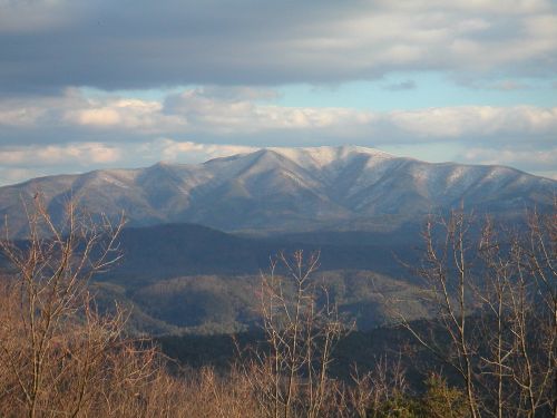
| Hike Summary: | Big Frog Mountain is located on the north edge of the Big Frog Wilderness Area and is part of the Cohutta Mountain District. This district contains the westernmost land over 4,000 feet in elevation in the eastern United States. To put it another way, no matter how far north you go within the United States, the terrain west of the Cohuttas does not rise to the 4,000 foot level again until it reaches the Great Plains, very far across the Mississippi. The heart of the Cohutta Mountains lie in the Cohutta-Big Frog Wilderness and straddles two states, two national forests, four counties, and two natural features, the Blue Ridge and the Tennessee Valley Divide. Tennessee's Cherokee National Forest manages all of the protected land north of the state line while Georgia's Chattahoochee National Forest administers all of the wildernesss below the border. Combined, the area of the Cohutta-Big Frog Wilderness at 45,059 acres is either the largest or second largest national forest wildernesss in the eastern United States. The only competitor in this ranking is New Hampshire's Pegigewasset Wilderness which is listed as the rounded off figure of 45,000 acres. This forest is roughly twice as long north to south as it is wide east to west. Its greatest width is approximately 8 1/2 miles while its maximum length from north to south is approximately 15 1/2 miles. Within this forest land, there are approximately 26 trails covering roughly 127 miles. Enjoy! Getting There The summit of Big Frog Mountain is somewhat unusual for this area in that several trails meet and connect very close to the highest point on the mountain. These trails are Wolf Ridge, Hemp Top, and Licklog Ridge. Depending on what trail(s) you take to the summit, the directions to the trailhead will vary. Please see the routes section for more details. Red Tape There are no fees or permits associated with any of the Big Frog Wilderness Trailheads. Camping Big Frog can be climbed at all times of the year. However, hikers should be aware that snow is regularly on the mountain from December to March, and they are well advised to contact the ranger station (contact information below) before setting off. Please be aware that bear are often seen in this area, and occasionaly are spotted roaming the Beech Bottom section of the Jacks River Trail. To avert bear problems, please 1) camp in less frequented areas, 2) hang your food (all of it, as well as toothpaste, etc.) from a high limb after supper, and 3) actively discourage bears from associating you (that is to say, humans) with food. If a bear comes in sniffing to your camp: yell, bang pots and pans together, throw rocks - do whatever you must short of harming the bear to make it leave. A bear that feeds off of human food eventually becomes habituated to humans, and will quickly become hunted and shot. Note: Due to over-use, all of the campsites within 1 mile (both upstream and downstream) of Jacks River Falls will be closed starting from June 1, 2006 to an undetermined point in the future. Routes Note: Routes are being added to the main page for the moment. If there is a strong desire, these can be seperated out into sub-pages. Wolf Ridge Trail Total Length to the top: 4.5 miles Wolf Ridge is the shortest and most difficult of the trails to the top of Big Frog Mountain. It gains ~2,500 feet (the most of any trail in both the Cohutta and Big Frog Wilderness areas) in a relatively short distance. For that reason, this trail is usually rated as moderate to strenuous. It is a ridgetop and upper-slope route. After the first mile, it follows the famous Blue Ridge, which doubles as the Tennesse Valley Divide. After Wolf Ridge turns east from its Chestnut Mountain Junction, the trail becomes distinctly different from all others in the wilderness. Here, near the end of the trail, the ridge often narrows to a topknot of rock with the trail snaking around the side of the rock as it heads up to the crest. Note: Wolf Ridge has no water on its own. You can find water at Elderberry Spring, slightly more than 0.1 mile down the uppermost end of the Licklog Ridge Trail. There are three main access routes to this trail-head: 1) From the three-way Forest Service Road 16 and Forest Service Road 17 intersection, continue straight ahead on FS 16 for approximately 5.5 miles to its junction with Forest Service Road 221, located on the Georgia-Tenessee border. This is right across the big iron bridge that goes over the Jacks River. Once across the river, stay straight on FS 221 for approximately 7.3 miles to the right turn onto FS 221E which leads uphill to the trailhead parking area and bulletin board. If you miss the trail sigh on FS 221, or if the sign is missing, you will come to FS 374 to the left side of the road a little more than 0.1 miles beyond the entrance to FS 221E. 2) From the three-way FS 55 - FS 221 intersection, turn left onto FS 221 and proceed approximately 4.3 miles |


There are no comments yet.