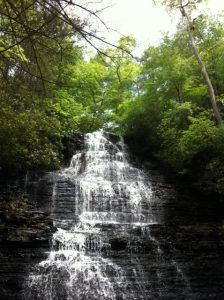
Benton Falls - Member Hike
| Hike Name: | Benton Falls |
|---|---|
| Country: | United States |
| State: | Tennessee |
| Nearby Town: | Ocoee, Benton |
| Rating: |  |
| Directions: | From Highway 64 - turn on to NFSR 77 (sign says Chilhowee Recreation Area) and drive 7.2 miles. Turn right into Chilhowee Day Use area (There is a $3 day use fee here). |
| Total Hike Distance: | 3.20 miles |
| Hike Difficulty: | Easy to Moderate |
| Permit Required: | No |
| Hike Type: | In & Out, Backtrack Hike |
| Hike Starts/Ends: | McCamy Lake |
| Trails Used: | Benton Falls Trail #131 |
| Backcountry Campsites: | No |
| Backcountry Water Sources: | Streams |
| Management: | U.S. Forest Service |
| Contact Information: | Ocoee / Hiwassee Ranger District 3171 Highway 64 Benton, TN 37370 (423) 338-3300 |
| Best Season: | Winter, Spring, Summer, Fall |
| Users: | Hikers, Bikers, Dogs |
| Road Conditions: | Primary Paved Roads, Secondary Paved Roads |
| Hike Summary: | The trail starts at McCamy Lake after walking across the dam. Due to a fire, a good section of the trail is not shaded. The trail is easy and rather flat until you get to the stone steps that descend to the bottom of the falls. While the trail itself is not a favorite, the falls more than make up for it. It is best viewed in the Spring and Fall, or after a good rainfall. |


There are no comments yet.