Alum Cave Bluffs, Great Smoky Mountains National Park - Member Hike
| Hike Name: | Alum Cave Bluffs, Great Smoky Mountains National Park |
|---|---|
| Country: | United States |
| State: | Tennessee |
| Nearby Town: | Knoxville, Gatlinburg, Asheville |
| Rating: |  |
| Directions: | trailhead is located about 2 miles from the Chimney Tops trailhead, on the same road. It is well marked and has ample parking area. |
| Total Hike Distance: | 4.40 miles |
| Hike Difficulty: | Moderate |
| Permit Required: | No |
| Hike Type: | In & Out, Backtrack Hike |
| Hike Starts/Ends: | 2 miles from the Chimney Tops trailhead |
| Trails Used: | Alum Cave Bluffs |
| Backcountry Campsites: | No |
| Backcountry Water Sources: | Streams, Springs |
| Management: | National Park Service |
| Contact Information: | By Mail Great Smoky Mountains National Park 107 Park Headquarters Road Gatlinburg, TN 37738 By Phone Visitor Information Recorded Message (865) 436-1200 By Fax 865-436-1220 |
| Best Season: | Spring, Fall |
| Users: | Hikers |
| Road Conditions: | Primary Paved Roads, Secondary Paved Roads |
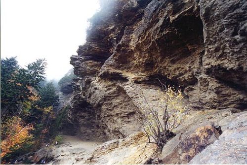
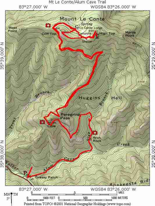
| Hike Summary: | Source: http://www.pearl56.addr.com/new_page_4.htm Alum Cave Bluffs is one of the more interesting and unusual trails in the Smokies. Its trailhead is located about 2 miles from the Chimney Tops trailhead, on the same road. It is well marked and has ample parking area. This trail has something to offer for everyone. While its length of over 4 miles may sound challenging, it is a relatively easy hike until the upper portion. The lower, beginning section is fairly level and very picturesque. It follows alongside Alum Cave Creek and features thick old-growth forest. At about the 1 mile point, you cross this creek by footbridge and start a slow incline. You pass an area which received a massive landslide in 1951, following an amazing downpour of 4 inches in an hour. The logs and debris still lie in the rocky washed-out area and you can only imagine what that flood must have been like, rushing down the mountainside. Shortly past this point, you again cross a footbridge, over Styx Branch and arrive at a natural rock arch in the side of the mountain. The trail continues through this arch and begins a more dramatic climb. The air temperature and decreasing density signal that you are definitely gaining altitude now. The trail follows around the face of the mountain and makes a hard right turn at a rocky precipice known as Inspiration Point, which offers stunning views of the surrounding area. It was rather hazy the day we were there, but nonetheless, this is a really neat area. It kind of had an eerie feel to it. But the footing is nice and level. Beyond this point however, the trail narrows and follows along a precarious edge. Thankfully, there are some hand cables along this portion to steady you and prevent falling off the edge. Once you reach the bluffs, it opens up and you can walk all around and beneath the cavernous rock formations. The bluffs here are unusual for the Smokies. The Cherokee revered this area and had legends associated with it. Later, the Confederate Army likewise revered this area, for its potential sulfur and saltpeter. They even constructed a small fort between this area and the Chimneys to guard the mining operation. As you can see, the hiking environment on this trail is widely varied and interesting. The first portion is an easy hike and scenic, even if you turn around at the Arch Rock. But if you take your time and go at a slow pace, the entire trail is very manageable. Again, take water and a snack and plan on 2 to 3 hours, depending on your pace. This is a good intermediate hike, not as hard as Chimneys, but tougher than Abrams Falls. This trail, like many others, continues onward and higher. In fact, it eventually leads to Mt. Leconte on the top of the mountains, which has cabins and a lodge. It is only accessible by foot and supplies are brought in by llama. The bluffs are about the halfway point. Birdshooter has been in this area quite a bit and is probably a very good source as well. |


There are no comments yet.