Foothills Trail - Section A4 to A8 - April 13, 2001 - Member Trip Report
| Hike Name: | Foothills Trail - Section A4 to A8 |
|---|---|
| Country: | United States |
| State: | North Carolina |
| Trip Rating: |  |
| Trip Date: | April 13, 2001 |
| Duration: | 4 days |
| Trail Conditions: | Excellent |
| Trail Traffic: | Light to Moderate |
| Trip Weather: | Sunny, Partly Sunny, Partly Cloudy, Cloudy |
| Trip Winds: | Light to Moderate |
| Trip Precipitation: | Rain, Showers, Thunderstorms |
| Trip Temperature: | High: 71-80, Low: 51-60 degrees Fahrenheit |
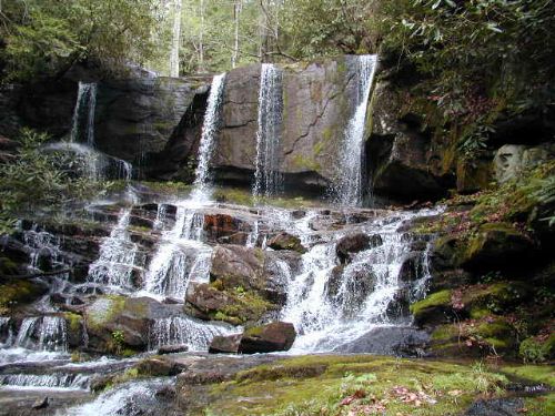
| Trip Report: | 4/13/01 (Friday): I left Atlanta by 7:30am to meet the others at the Upper Whitewater Falls trailhead off NC 281. Arrived in the rain around 9:45am to find The Camel and Russ/Laurie in the parking lot. The Kidd/Kathy showed up about fifteen minutes later and we left two cars behind and drove my SUV and Russ/Laurie’s pick-up to the eastern trailhead off Highway 178 by noon. It was still raining slightly when we parked and started the 32 mile hike. Fortunately, the drizzle stopped within 30 minutes and cleared to mostly sunny skies by mid-afternoon. By 2pm it was in the 70’s and fairly hot, so we stopped for a break at Laurel Fork Creek and climbed under a 25 foot waterfall to cool off (at the 4.7 mile mark.) We did 7.5 miles today and camped at the top of the Laurel Fork Falls (which have been dangerous to hikers in the past). All of us were pretty beat by the time we pitched camp. We basically sat around on our Thermarests until dinner. There were two other groups camped near us this evening and we saw more people on the trail than I had expected. I guess the three day weekend and the recent press on this section has made it more popular than in the past. The sunset looked awesome this evening, but I was too tired to get up and check it out from the top of the falls (although the view is impressive). After dark the stars were out in force, and it was a nice night to sit around The Camel’s blazing campfire. He mastered a new trick tonight using his propane camp stove to start the fire. Temps bottomed out overnight at 51.4F at 7:15am on 4/14. 4/14/01 (Saturday): We got a late start this morning (around 10:30am) and after an easy hike down from Laurel Fork Falls had a brutal climb up the ridge overlooking Lake Jocassee. The suspension bridge over the Toxaway River was very cool however, and is the longest on the Foothills Trail at 225 feet. We took a long break immediately after it near the Canebrake boat access ramp. The water was very low, and most of the boaters had to park about a mile away from the bridge and hike to it. Fish were spawning in the shallows of the lake and we watched as they continued to thrash around for about an hour. We also spotted a deer and her fawn grazing in the dried flats of the lake. None of us looked forward to the final 5.3 miles to Bear Creek where we camped for the night. The Camel blazed the trail and radioed back to us that he had found a nice spot just past the other group that camped near us last night. The site was in a hollow with no views, but it was flat and had a decent creek within 10 yards of the firepit. Temps were in the 50’s again tonight. 4/15/01 (Sunday): We had another 10:30am start today and hit the trail right as the rain started in a slow drizzle. It eventually picked up to a steady downpour that lasted for an hour or two. The crossing of the 115 foot bridge on the Horsepasture River was a wet one. We paused briefly to shoot a few pictures, but moved on quickly. Fortunately, the rained stopped by the time we hit the Bearcamp Creek campsite (not to be confused with Bear Creek). So we took a lunch break and dried out briefly before hitting the trail again. The Camel and I took a side trip to see Hillard Falls which was well worth the 0.3 mile hike. There are two sets of falls. The lower falls are small and not very impressive. We almost missed the main falls which were further up the side trail and hidden behind some large trees. After the heavy rains, both falls were running pretty fast and there was a nice wadding pool and nearby campsite that are worth returning to in the future. The Kidd, Kathy, Russ and Laurie got ahead of us as a result of the side trip. We eventually caught them after a tough climb up to a logging road over many steps. (The trail maintainers must have worked their cans off on this trail. There are a lot of steps and bridges which clearly took a lot of man hours to build.) We eventually made it to the Thompson River and ran into the group that we had seen each of the previous nights but they planned to hike out today. We took a long break in the area and decided to hike out tomorrow (and stay at the campsite at the 15.8 mile mark on map #8). I decided to take an extended rest at the Thompson River because it was so scenic. It is a great campsite but there is only room for a few tents. The others hiked on and had set up camp by the time I arrived. Unfortunately, the water source was horrible but the campsite was roomy and flat. We had a fire again tonight and celebrated our last night on the trail. 4/16/01 (Monday): The hike back to the Upper Whitewater Falls lot was much easier than any of us anticipated. The weather cleared for our last day on the trail, and it was sunny and warm all day. If we had parked at the Bad Creek Access trailhead, we could easily have made it out of here last night. The views of the lower overlook of Whitewater Falls made it worth the t |

 Trail Map For This Area
There are no comments yet.