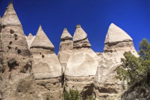
Kasha-Katuwe Tent Rock - Member Hike
| Hike Name: | Kasha-Katuwe Tent Rock |
|---|---|
| Country: | United States |
| State: | New Mexico |
| Nearby Town: | Sante Fe |
| Rating: |  |
| Directions: | Take the Cochiti Reservoir exit from I-25 to NM Route 22 and follow the signs to Cochiti Pueblo. Turn right at the pueblo water tower onto Tribal Route 92 (connects to Forest Service Road 266). Travel 5 miles to the Tent Rocks parking area |
| Total Hike Distance: | 2.40 miles |
| Hike Difficulty: | Easy to Moderate |
| Permit Required: | No |
| Hike Type: | In & Out, Backtrack Hike |
| Hike Starts/Ends: | Tent rock parking area |
| Trails Used: | Tent Rocks |
| Backcountry Campsites: | No |
| Backcountry Water Sources: | None |
| Management: | State Park Service |
| Contact Information: | Unknown |
| Best Season: | Winter, Spring, Fall |
| Users: | Hikers |
| Road Conditions: | Primary Paved Roads |
| Hike Summary: | Travel through a slot canyon and climb among rock formations shaped like tents up to a mesa overlooking the surrounding mountains. |


There are no comments yet.