Eastatoe Creek - Member Hike
| Hike Name: | Eastatoe Creek |
|---|---|
| Country: | United States |
| State: | South Carolina |
| Nearby Town: | Salem, SC |
| Rating: |  |
| Directions: | From the intersection with Hwy 11, drive north on US 178 to the bridge over Eastatoe Creek (approximately one mile past the community of Rocky Bottom). Cross the bridge and turn left at the Laurel Valley Lodge sign. Immediately bear right onto the unpaved fork and continue to the Foothills Trail parking area about 0.3 mile on the left. Park here, and hike another 0.2miles up the unpaved road. The Eastatoe Creek Trail-head will be on your left. From Pickens, SC, drive north on US 178 to the bridge over Eastatoe Creek (approximately one mile past the community of Rocky Bottom). Cross the bridge and turn left at the Laurel Valley Lodge sign. Bear right onto the unpaved fork (The road sign reads Horsepasture Road, but the sign is frequently knocked down.) and continue to the Foothills Trail parking area on the left. Follow the yellow blazes on trees for about 0.1 mile and turn left (south) onto an old logging road marked by a cable gate |
| Total Hike Distance: | 5.00 miles |
| Hike Difficulty: | Moderate to Difficult |
| Permit Required: | No |
| Hike Type: | In & Out, Backtrack Hike |
| Hike Starts/Ends: | Foothills Trail/Eastatoe Creek Parking Area |
| Trails Used: | Eastatoe Creek Trail |
| Backcountry Campsites: | Yes |
| Backcountry Water Sources: | Streams |
| Management: | State Forest Service |
| Contact Information: | South Carolina Department of Natural Resources 311 Natural Resources Drive Clemson, South Carolina 29631 864-654-6738 |
| Best Season: | Winter, Spring, Summer, Fall |
| Users: | Hikers, Dogs |
| Road Conditions: | Primary Paved Roads, Secondary Paved Roads, Maintained Gravel or Dirt Roads |
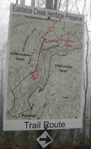
| Hike Summary: | Eastatoe Creek Heritage Preserve is a 373-acre wilderness west of Rocky Bottom, S.C. which protects a five-mile stretch of Eastatoe Creek and three of its tributaries. The stream lies in a gorge surrounded by rocky cliff faces that is accessed via an old logging road which descends gradually toward the ravine. The final mile of the hike is a steep descent that passes through an old-growth hardwood forest, and arrives at a self-sustaining rainbow trout stream. It is said that Eastatoe Gorge has rare species of moss that occur nowhere else in the world. The Eastatoe Creek trail is blazed in yellow and is well marked. When you reach the stream, follow signs to The Narrows for access to a platform that overlooks a waterfall. The creek has cut a narrow path through the surrounding stone and the water drops dramatically in to a small pool then continues over a series of two additional waterfalls which are spectacular after a heavy rain. The lower falls require some off-trail hiking - and are not for the weary. |
Recommended
Trip Reports
There are no Trip Reports yet.


 Trail Map For This Area
There are no comments yet.