Torrey Pines State Reserve - Member Hike
| Hike Name: | Torrey Pines State Reserve |
|---|---|
| Country: | United States |
| State: | California |
| Nearby Town: | La Jolla |
| Rating: |  |
| Directions: | From La Jolla, take I-5 north to exit 33B. At the end of the exit, turn left on Carmel Valley Road. Travel approximately 1.6 miles, and turn left on North Torrey Pines Road. Go a short 0.4 miles, and arrive at the park entrance. |
| Total Hike Distance: | 3.00 miles |
| Hike Difficulty: | Easy |
| Permit Required: | No |
| Hike Type: | Roundtrip, Loop Hike |
| Hike Starts/Ends: | Visitor Center |
| Trails Used: | Razor Point, Beach, Broken Hill, and South Fork |
| Backcountry Campsites: | No |
| Backcountry Water Sources: | None |
| Management: | State Park Service |
| Contact Information: | Location: 12600 North Torrey Pines Road San Diego, California 92037 GPS: 32.92183, -117.2497 Mailing Address: Torrey Pines State Reserve California State Parks San Diego Coast District North Sector 2680 Carlsbad Boulevard Carlsbad, California 92009 Phone: (858) 755-2063 Website: www.torreypine.org/index.html |
| Best Season: | Winter, Spring, Summer, Fall |
| Users: | Hikers |
| Road Conditions: | Primary Paved Roads, Secondary Paved Roads |
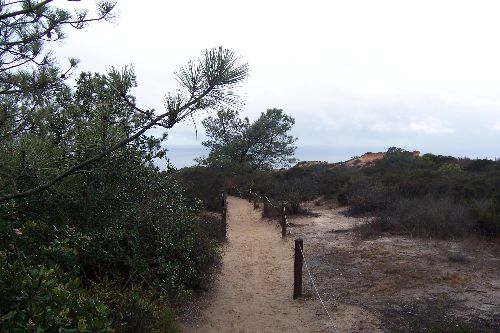
| Hike Summary: | Torrey Pines State Reserve is a day-use park that is home to its namesake tree, the Torrey Pine. The trees themselves were identified in the mid 1800s as a separate species of pine that grows naturally only along a small strip of coast from Del Mar to La Jolla, and on Santa Rosa Island, which lies off in the sea about one hundred and seventy miles to the northwest. The Torrey Pine is the rarest pine in the United States and one of the rarest pines in the world. The terrain of the Reserve is quite varied. The sand and clay of beaches and lagoons of fifty million years ago have become sandstone and have been raised far above sea level by tectonic forces. The main entrance road, from North Torrey Pines Road to the Visitor Center, rises three hundred feet in 0.8 miles. There are sections of hiking trails that parallel the bluff edge high above the sea, and there are several viewing platforms built right at the bluff edge. This particular hike consists of a 3-mile counterclockwise loop that is accomplished by combining portions of the razor point, beach, broken hill, and south fork trails with the Torrey Pines Park Road. The loop starts and ends at the trailhead located in the parking lot across from the Visitor Center. The Razor Point Trail splits off to the right from the Beach Trail approximately 200 yards below the trailhead, but ultimately winds back, and reconnects with the Beach Trail just beyond the branch for the Yucca Point Trail. From here, the Beach Trail descends toward both the beach access point and the intersection with the Broken Hill Trail. The views of the ocean are spectacular, and the landscape is a stark contract to that of the Midwest. Before continuing back on the Broken Hill and South Fork Trails, it is well worth the time to head down to the beach to observe the broken cliffs along the waterfront. |


There are no comments yet.