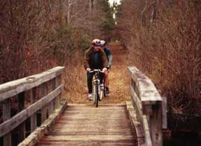
Swamp Fox Passage of the Palmetto Trail - Member Hike
| Hike Name: | Swamp Fox Passage of the Palmetto Trail |
|---|---|
| Country: | United States |
| State: | South Carolina |
| Nearby Town: | Charleston/ Moncks Corner |
| Rating: |  |
| Directions: | To the Eastern trailhead: From Charleston, drive north on US 17 to Steed Creek Road (Charleston County Road S-10-1032) in Awendaw. Look for the trailhead parking area on US 17 just beyond Steed Creek Road. To the Western trailhead: From Moncks Corner, drive north on US 52 for approximately 5 miles to the Canal Recreation Area on the right. |
| Total Hike Distance: | 42.00 miles |
| Hike Difficulty: | Moderate |
| Permit Required: | No |
| Hike Type: | One-Way, Shuttle Hike |
| Hike Starts: | Steed Creek Rd Parking Area or Moncks Corner |
| Hike Ends: | Steed Creek Rd Parking Area or Moncks Corner |
| Trails Used: | Swamp Fox Passage of the Palmetto Trail |
| Backcountry Campsites: | No |
| Backcountry Water Sources: | Streams, Rivers, Lakes, Springs |
| Management: | State Park Service |
| Contact Information: | Francis Marion National Forest, Witherbee Ranger District, 2421 Witherbee Road, Cordesville, S.C. 29434. 843-336-3248. Also try the Sewee Visitor & Environmental Education Center, 5821 Hwy. 17 N, Awendaw, SC 29429, 843-928-3368. Or: Palmetto Conservation Foundation, 1314 Lincoln St., Suite 305, Columbia, SC 29201-3154, or Trail Talk South Carolina State Trails Program South Carolina Department of Parks, Recreation and Tourism 1205 Pendleton Street :: Columbia, SC 29201 :: 803-734-0173 |
| Best Season: | Winter, Spring, Summer, Fall |
| Users: | Hikers, Bikers |
| Road Conditions: | Primary Paved Roads, Secondary Paved Roads |
| Hike Summary: | The Swamp Fox Trail is one of the Lowcountry’s oldest trails. It offers a long, flat out-and-back journey through the swampy wetlands and coastal pine forests of Francis Marion National Forest. When Revolutionary War General Francis Marion sought refuge from British troops in the state’s Lowcountry swamps, he earned the nickname “Swamp Fox.” His guerilla tactics and legendary reputation eventually led Boy Scout leaders to name this trail after Marion when it was built in 1968. As far back as the late nineteenth century, logging companies had already moved into the area, eventually developing a 300-mile network of railbeds for their logging trains. The network was abandoned during the 1920s; a decade before the Forest Service purchased the land. Today, the elevated railways make fine hiking and mountain biking paths in stretches that are swampy, while boardwalks and footbridges help elsewhere. No equestrian or off-road vehicle use is permitted. Deer, wild turkey, songbirds, and waterfowl are abundant along the trail. There are two trailheads, and either one will provide you with an enjoyable hike and diverse views. Of note is the Wadboo Swamp (which should be avoided after rain) near the western entrance at Canal Recreation Area, and the grassy savanna around Dog Swamp and Turkey Creek. For additional information from Palmetto Trail users: Trail Talk No Fees Camping: There is primitive camping available at Halfway Creek and several other sites along the trail, but camping is limited to designated areas, and the cutting of live trees for firewood is prohibited. The Halfway Creek Campground is on Steed Creek Road, 5 miles from the Eastern trailhead. Trail Map located at: http://www.sctrails.net/TRAILS/MAPS/SwampFoxPassmap.html This is one I'm going to have to do soon, I'll keep you updated. |
Recommended
Trip Reports
There are no Trip Reports yet.


 Trail Map For This Area
There are no comments yet.