Edward Ball Wakulla Springs State Park - Member Hike
| Hike Name: | Edward Ball Wakulla Springs State Park |
|---|---|
| Country: | United States |
| State: | Florida |
| Nearby Town: | Wakulla Springs |
| Rating: |  |
| Directions: | Traveling East on I-10 to new Exit 196 (old Exit 28). Take SR-263 (Capitol Circle) South 12 miles. Turn right (South) onto US-319/SR-61 (Crawfordville Hwy) for 2 miles. Bear left onto SR-61(Wakulla Springs Rd) for 6 miles. Turn left onto SR-267 at flashing stop light. Turn Right into Park entrance. From West I-10 use new Exit 203(old Exit 30). Take SR-61 (Thomasville Rd) South. Continue on SR-61 thru Tallahassee for 10 miles. Take US-319/SR-61 (Crawfordville Hwy) South for 2 miles. Bear left onto SR-61(Wakulla Springs Rd) for 6 miles. Turn left onto SR-267 at flashing stop light. Turn Right into Park entrance. Park Fees Admission Fees - $4.00 per vehicle Pedestrians, Bicyclists, Extra Passengers, Passengers In Vehicles With Holder of Annual Individual Entrance Permit - Admission Fee $1.00 Guest Rooms $85.00 - $105.00 Boat Tour Fees Adult Tour $6.00 Child Tour, children 12 and under $4.00 Charter Boat Tour $200.00 Pontoon Charter $50.00 |
| Total Hike Distance: | 16.00 miles |
| Hike Difficulty: | Easy to Moderate |
| Permit Required: | No |
| Hike Type: | Roundtrip, Loop Hike |
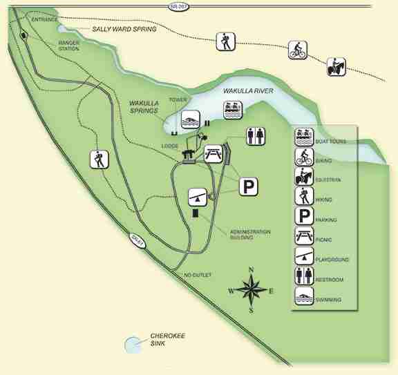
| Hike Starts/Ends: | Parking areas at either the Administration Building or Lodge |
| Trails Used: | St Marks |
| Backcountry Campsites: | No |
| Backcountry Water Sources: | None |
| Management: | State Park Service |
| Contact Information: | Edward Ball Wakulla Springs State Park 550 Wakulla Park Drive Wakulla Springs, Florida 32327 Phone: 850-224-5950 Fax: Contact Park for Number Citizen Support Organization Friends of Wakulla Springs State Park, Inc. 550 Wakulla Park Drive Wakulla Springs, FL, 32327-0390 |
| Best Season: | Winter, Spring, Summer, Fall |
| Users: | Hikers, Bikers, Dogs, Horses |
| Road Conditions: | Primary Paved Roads, Secondary Paved Roads, Maintained Gravel or Dirt Roads |
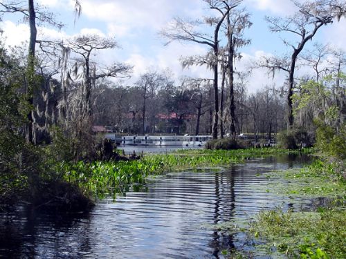
| Hike Summary: | lorida's first designated state trail follows the abandoned railbed of the historic Tallahassee-St. Marks Railroad. The trail runs almost due south from Tallahassee to the town of St. Marks, which is at the confluence of the St. Marks and Wakulla rivers. The Tallahassee-St. Marks Railroad was the first railroad under construction in Florida and the first in the nation to receive a federal land grant. Completed in 1837, the 20-mile line connected the territorial Capital with the Gulf port of St. Marks. Conceived and financed by leading planters and merchants, the railroad transported the prosperous cotton crop of the region for shipment to East Coast markets. Initially, mules hauled open freight and passenger cars loaded with naval store and timber industry products. The rickety railbed prompted an earlier traveler to describe it as "the worst that has yet been built in the entire world." In the 1850s, the railroad was modernized and used to transport cotton. The Tallahassee-St. Marks railroad was distinguished as Florida's longest operating line, serving for 147 years. It is of rich historical significance as a pioneer enterprise that stimulated the region's commercial development and settlement. In 1984, the Florida Department of Transportation purchased 16 miles of the corridor to preserve the right-of-way. The recreational trail was constructed and is maintained by the Florida Park Service. The southern two miles of the trail has been designated a segment of the Florida National Scenic Trail, which continues on the other side of the St. Marks River to historic Port Leon and beyond. Hail a passing fisherman for a ride across the river. The 16-mile paved St. Marks Trail follows the historic Tallahassee-St. Marks Railroad line, passes through part of the Apalachicola State Forest and terminates at the small coastal village of St. Marks. The City of Tallahassee has extended this trail approximately 5 miles to the north into Tallahassee. Activities permitted on the trail include bicycling, walking, jogging, skating, dog walking and horseback riding. A paved surface is available for pedestrians and cyclists. An adjacent trail is available for horses and their riders. Horseback riding should be confined to the designated trail or shoulder areas to avoid damaging the smooth bicycling surface. This site opens at 9 a.m. and closes at 5 p.m. year-round. A paved parking lot is located on State Road 363, just south of Tallahassee at the entrance of the trail. |


There are no comments yet.