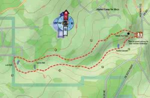
Lost Falls Trail - Member Hike
| Hike Name: | Lost Falls Trail |
|---|---|
| Country: | United States |
| State: | Alabama |
| Nearby Town: | DeSoto State Park (Fort Payne, AL) |
| Rating: |  |
| Directions: | From Fort Payne take AL 35 East 10 miles and make a left turn onto DeSoto Parkway. Travel 5.1 miles (along the way DeSoto Parkway turns into CR 89) to the park entrance. Continue straight another 1.6 miles. The trailhead is to the right. Another half-mile down the road and you will come to the park headquarters and camp store. |
| Total Hike Distance: | 3.20 miles |
| Hike Difficulty: | Easy to Moderate |
| Permit Required: | No |
| Hike Type: | Roundtrip, Loop Hike |
| Hike Starts/Ends: | 1.6 miles from park entrance on rt |
| Trails Used: | Lost Falls Trail |
| Backcountry Campsites: | No |
| Backcountry Water Sources: | Streams, Springs |
| Management: | State Park Service |
| Contact Information: | DeSoto State Park (205) 845 - 5075 http://www.desotostatepark.com Services: The Great Outdoors Store, 2207 Gault Ave. N., Ste F, Fort Payne, AL 35967 (256) 845-9398 |
| Best Season: | Winter, Spring, Summer, Fall |
| Users: | Hikers |
| Road Conditions: | Primary Paved Roads, Secondary Paved Roads |
| Hike Summary: | Camping Info: A primitive tent campsite is available for $5/night per person. RV sites are also available starting at $16/night. Improved sites with water and electricity are $16/night. Cabins and motel are also available in the park. Wildflower / Rhododendron Season – Wildflowers bloom late April through June, rhododendron historically the third week of May. Fall Foliage – The peak of the season is generally the third week of October. Geological diversity, breathtaking wildflowers in the spring, fall foliage in the fall, snow in the winter, and waterfalls. Any time of year, DeSoto State Park lives up to its name as "The Home of Mother Nature," and the Lost Falls Trail is a fantastic way to take in a little bit of all that nature has to offer in the park. This easy-to-moderate 3.2-mile loop will take you past such interesting geologic features as Needle Eye Rock and CR Caves. Needle Eye is a huge boulder split neatly in half. CR Caves is not really a cave but more a series of impressive rock overhangs, some 50 feet deep, that have been created over thousands of years by the action of the Laurel Creek. Then there are the waterfalls. DeSoto and the surrounding area is a waterfall lover's dream come true, and the Lost Falls Trail highlights three within the park. The first is Laurel Falls, named for the creek that creates this cascade. While the view is nice from the side trail that leads to the falls, try a little bushwhacking for better views near the base of the falls. The 60-foot falls are framed by layers of jagged rock. A pool at the base is an excellent spot for lunch. But remember to be careful of your footing! The next falls are the trail's namesake, Lost Falls. Again, a short side trail takes you to the falls which is about 50 feet tall. You will have to carefully cross the creek at the head of the falls for the return trip. Just before returning to the trailhead you will come to the last of the water show on this trip, Azalea Cascade. Framed by rhododendron, Azalea is the smallest of the three falls on this trip, about 30 feet tall, but still wonderful. A small wooden footbridge leads across the pool at the base of the falls for a good look. |


There are no comments yet.