Starr Mountain, Purple Blaze - Member Hike
| Hike Name: | Starr Mountain, Purple Blaze |
|---|---|
| Country: | United States |
| State: | Tennessee |
| Nearby Town: | Etowah |
| Rating: |  |
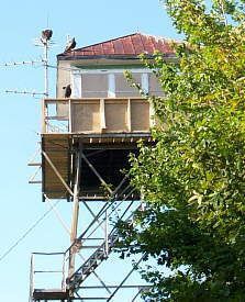
| Directions: | From Etowah, HWY 411, to Mecca Pike. Continue on Mecca Pike towards Tellico Plains. About 1/2 mile on the right you will see a sign for Starr Mtn. Drive up the mountain, you will see a fork in the road to either continue straight or turn right, Turn Right and continue until you pass the abandoned fire towere, you will have to look for the antennaes and towers in the winter, summer look for the open access road that goes up the hill on the right side for the tower. Continue past the fire tower and park at the next closed road with a gate on the right. The trail is actually a fire road that's in good shape. We didn't go the whole route so I don't know how long it really is. Nice views of the valley and you can hear cows in the distance. We walked at least 3 miles and didn't get to the end. Nice gradual uphill climb on the return trip. |
| Total Hike Distance: | 6.00 miles |
| Hike Difficulty: | Easy |
| Permit Required: | No |
| Hike Type: | In & Out, Backtrack Hike |
| Hike Starts/Ends: | Fire access road near Fire Tower |
| Trails Used: | Purple Blaze |
| Backcountry Campsites: | No |
| Backcountry Water Sources: | Streams, Springs |
| Management: | National Park Service |
| Contact Information: | Unknown |
| Best Season: | Winter, Spring, Summer, Fall |
| Users: | Hikers, Bikers, Dogs, Horses |
| Road Conditions: | Maintained Gravel or Dirt Roads, Four Wheel Drive Recommended, High Clearance Vehicle Recommended |
| Hike Summary: | Lots of deer tracks and pig hair along the road. Evidence of horses and mountain bikers. Didn't see a soul the entire time. Bullet Creek Trail might be better, will try and do that one tomorrow and will let you know about it. Nice quiet hike along a wide road with good scenery. |


There are no comments yet.