Bald River Falls - Member Hike
| Hike Name: | Bald River Falls |
|---|---|
| Country: | United States |
| State: | Tennessee |
| Nearby Town: | Tellico Plains, Tn |
| Rating: |  |
| Directions: | Drive 5.25 miles east of Tellico Plains on SR 165 and turn right onto Tellico River Road and drive 5.9 miles to parking. Handicapped Accessible. |
| Total Hike Distance: | 2.00 miles |
| Hike Difficulty: | Easy to Moderate |
| Permit Required: | No |
| Hike Type: | In & Out, Backtrack Hike |
| Hike Starts/Ends: | BRF parking |
| Trails Used: | BRF |
| Backcountry Campsites: | No |
| Backcountry Water Sources: | Streams, Springs |
| Management: | National Park Service |
| Contact Information: | Unknown |
| Best Season: | Winter |
| Users: | Hikers, Dogs |
| Road Conditions: | Primary Paved Roads, Maintained Gravel or Dirt Roads |
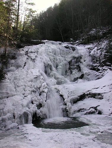
| Hike Summary: | Although they are not directly on the Cherohala Skyway, the Bald River Falls are a gorgeous spot with plenty of scenic outdoor attractions. Visitors can view the falls from the road, or park and walk to enjoy them. Beautiful in the summer, the falls are entrancing in the winter when they are covered in ice. Located in Cherokee National Forest, just South of Great Smoky Mountains National Forest. |

Recommended


Trip Reports
| Date | Rating | Duration | Hiker | |
|---|---|---|---|---|

|
December 26, 2006 |  |
2 hours | Tree Top Flyer |

|
December 25, 2003 |  |
6 hours | Tree Top Flyer |
2 replies on “Bald River Falls - Member Hike”
This was not my photo, most of my hiking photos have been deleted from the computer by a person who wishes to remain anonymous, okay I goofed. I have hiked the falls area in every season and seen the ice just as bad…muy muy frio, but it keeps the drinks cold.
Great photo! Looks like it was a cold hike.