Chino Hills State park- Diemer loop - Member Hike
| Hike Name: | Chino Hills State park- Diemer loop |
|---|---|
| Country: | United States |
| State: | California |
| Nearby Town: | Yorba Linda |
| Rating: |  |
| Directions: | 91 Fwy off at Yorba Linda Blvd |
| Total Hike Distance: | 5.28 miles |
| Hike Difficulty: | Moderate |
| Permit Required: | No |
| Hike Type: | Roundtrip, Loop Hike |
| Hike Starts/Ends: | Rim Crest Drive Trailhead |
| Trails Used: | South Ridge Trail, Diemer Trail, Telegraph Canyon Trail, Little Canyon trail |
| Backcountry Campsites: | No |
| Backcountry Water Sources: | Streams |
| Management: | State Park Service |
| Contact Information: | Chino Hills State Park 1879 Jackson Street Riverside, CA 92504 (909)780-6222 |
| Best Season: | Winter, Spring, Fall |
| Users: | Hikers, Bikers, Horses |
| Road Conditions: | Primary Paved Roads |
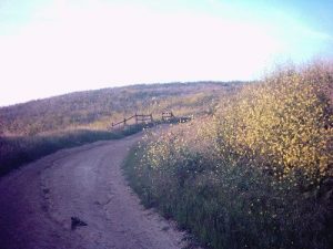
| Hike Summary: | This is a loop hike beginning at rimcrest Drive Trailhead. This is one of many variations possible within this end of Chino Hills State park. This loop hike can be done in either direction. Which direction you choose determines whether it is a mostly uphill, or mostly downhill hike. The trail itself is a fire road. South ridge trail looks down into Telegraph canyon, and views of Orange county, and beyond can be seen. Walking down into Telegraph canyon, the sounds of roads and freeways disappear. This is the highlight of the hike. Despite the prescence of mountain bikers and hikers, you get a feeling of seclusion. You walk the length of the canyon, and climb out the opposite end of the loop. Both Diemer, and little canyon trails are short but steep. You finish your hike on South Ridge trail. You continue back to the trailhead. |


There are no comments yet.