Cohutta Wilderness - Jacks River - Member Hike
| Hike Name: | Cohutta Wilderness - Jacks River |
|---|---|
| Country: | United States |
| State: | Georgia |
| Nearby Town: | Chatsworth |
| Rating: |  |
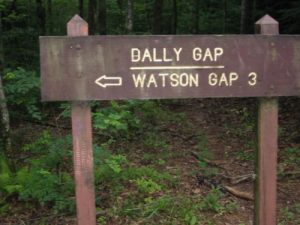
| Directions: | From the intersection of Forest Road 221, 65, and Georgia County Road 251 go across the bridge over Tumbling Creek and continue southbound on Forest Road 65 (which becomes Forest Road 22) for about eight miles until you reach Dally Gap. Forest Road 65 turns to dirt and gravel after a half a mile and enters Georgia as Forest Road 22. Head downhill to the Jacks River from the trailhead at Dally Gap. |
| Total Hike Distance: | 4.60 miles |
| Hike Difficulty: | Easy to Moderate |
| Permit Required: | No |
| Hike Type: | In & Out, Backtrack Hike |
| Hike Starts/Ends: | Dally Gap (USFS 22) |
| Trails Used: | Jacks River Trail |
| Backcountry Campsites: | No |
| Backcountry Water Sources: | Streams, Rivers |
| Management: | U.S. Forest Service |
| Contact Information: | Cohutta Wilderness Area National Forest Service 401 Old Ellijay Road Chatsworth, GA 30705 (706) 695-6736 |
| Best Season: | Winter, Spring, Summer, Fall |
| Users: | Hikers, Dogs, Horses |
| Road Conditions: | Primary Paved Roads, Secondary Paved Roads, Maintained Gravel or Dirt Roads |
| Hike Summary: | The Cohutta Wilderness at 36,977 acres is the largest National Forest Wilderness in the southeast and combined with the Big Frog Wilderness in Tennessee the area is some of the most pristine and isolated in the South. Both the Conasauga and Jacks Rivers are stocked with trout and have great fishing. There's also numerous sand bars, waterfalls, pools, and campsites along the rivers which makes this a very popular overnight destination. This is an easy backtrack hike from Dally Gap in the Cohutta to the Jacks River. It can be done as either a day or overnight hike. |
Recommended
Trip Reports
| Date | Rating | Duration | Hiker | |
|---|---|---|---|---|

|
January 18, 2008 |  |
1 day | jethro |
|
July 6, 2003 |  |
2 hours | The Operator |


There are no comments yet.