Sierra Madre to Orchard Camp - Member Hike
| Hike Name: | Sierra Madre to Orchard Camp |
|---|---|
| Country: | United States |
| State: | California |
| Nearby Town: | Sierra Madre |
| Rating: |  |
| Directions: | 210 Fwy Exit Bailey ave in Sierra Madre. Head North to Mira Monte Turn Right. Park on Street just below Mt. Wilson Trail. Do not park on Mt. Wilson trail, it is a private street. |
| Total Hike Distance: | 7.00 miles |
| Hike Difficulty: | Easy to Moderate |
| Permit Required: | No |
| Hike Type: | In & Out, Backtrack Hike |
| Hike Starts/Ends: | Sierra Madre |
| Trails Used: | Historic Mount Wilson Trail |
| Backcountry Campsites: | No |
| Backcountry Water Sources: | Streams |
| Management: | City Park Service |
| Contact Information: | City of Sierra Madre |
| Best Season: | Winter, Spring, Fall |
| Users: | Hikers, Dogs |
| Road Conditions: | Primary Paved Roads |
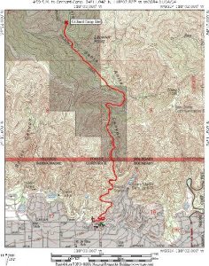
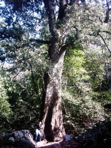
| Hike Summary: | #39 in John W. Robinsons “Trails of the Angeles” 7 Miles In and Back Elevation Gain/Loss=1990’ The Mount Wilson trail is a throwback to a bygone era. The trail’s history begins with The Gabrielino Indians, who were believed to have trekked through the area in search of acorns and wild game. The trail was officially constructed under the direction of Benjamin Wilson in 1864. The purpose at that time was to transport lumber from what was later named “Mt. Wilson”. The trail was later (1889) used to transport the first of many telescopes to the mountaintop. The second telescope was carried up the trail and assembled atop Mount Wilson. The second telescope facilitated widening of the trail, similar to what exists today. Orchard Camp was constructed in 1864 as a construction camp for laborers. Around 1890 the camp was converted to a trail resort. It was immensely popular throughout most of it’s 50 years of operation. 1911 was a peak year with 40,000 persons signing the register. Those days are gone now but, you can still see the remains of Orchard camp. The site was abandoned in 1940. All that remains are stone foundations. The biggest attraction is the 1,500 year old Canyon Oak, looming above the site. The hike begins in the city of Sierra Madre. The trailhead is located just up Mount Wilson Trail Drive. You pass the trail museum as you walk up. There are maps and friendly advice available. At the trailhead, there is a sign with points of interest and mileages. The trail is well signed throughout. Continue up-canyon from the trailhead. The views of the canyon below are nice. You can see the Sierra Madre Dam at the mouth of the canyon. The first 1.5 miles to first water are entirely exposed to the sun. An early morning start is advisable on hot days. You soon reach first water. A short walk down to the stream provides a tranquil resting spot. You can take the canyon as an alternative route however I have not done it and am unsure of the trail conditions. It’s best to ask at the trail museum if you plan to take any alternative routes. The topo maps do not adequately show other routes. From first water continue your uphill climb. You will pass an unsigned canyon meeting the trail from the left. The canyon connects to a trail running up from Jones peak. A short distance ahead, a short path branches from the right. This is the Helispot (2.7miles from trailhead). This is a nice side trip, and is just a few short yards off the main trail. You step out onto an exposed nub. The area is a flat round shoulder sticking out of the mountain. If it were a bit larger you could imagine a helicopter landing here (hence “helispot”). You get a good 270° view of the area from here. Once past the Helispot look for a small green three mile marker to the left of the trail. You will be traveling through a fairly dense forest, with some much welcomed shade. You will descend the canyon for a while until you meet with Decker Spring (3.1 miles from trailhead). Crossing the spring, you then begin to ascend slightly. The .4 miles to Orchard camp follow quickly and you meet a signed trail junction. Continue straight just a few yards. Under the shade of a massive 1500 year-old oak are the remnants of Orchard Camp. The site seems remarkably small for a camp, but overgrowth and landslides have closed in over time. The stream runs alongside, making this a very pleasant place to relax and enjoy. At 3.5 miles orchard Camp is the halfway point to Mt. Wilson. Return the way you came. Interesting links: http://www.dankat.com/mstory/trail.htm http://www.greatoutdoors.org/oclb/obsolete/orchardcamp/ http://english.glendale.cc.ca.us/mwtrail061502.html http://www.simpsoncity.com/hiking/orchard.html |


One reply on “Sierra Madre to Orchard Camp - Member Hike”
The exit off the freeway is Baldwin, not Bailey. (Bailey CANYON is another nearby trail)