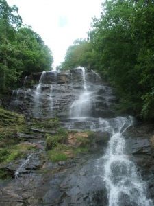
Amicalola Falls Canyon Climbers - Member Hike
| Hike Name: | Amicalola Falls Canyon Climbers |
|---|---|
| Country: | United States |
| State: | Georgia |
| Nearby Town: | Dawsonville |
| Rating: |  |
| Directions: | Located 15 miles northwest of Dawsonville on Ga. Hwy. 52. Take Hwy. 53 west to Hwy. 183 north to Hwy. 52 east. |
| Total Hike Distance: | 2.00 miles |
| Hike Difficulty: | Moderate to Difficult |
| Permit Required: | No |
| Hike Type: | Roundtrip, Loop Hike |
| Hike Starts/Ends: | Visitor Center |
| Trails Used: | Appalachian Approach Trail to top of falls including 604 stairs, take East Ridge Trail back to visitor center |
| Backcountry Campsites: | No |
| Backcountry Water Sources: | None |
| Management: | State Park Service |
| Contact Information: | Address/Directions Amicalola Falls State Park and Lodge 418 Amicalola Falls State Park Rd Dawsonville , GA 30534 Park (706) 265-4703 http://www.gastateparks.org/info/amicalola/ |
| Best Season: | Spring, Summer, Fall |
| Users: | Hikers |
| Road Conditions: | Primary Paved Roads, Secondary Paved Roads |
| Hike Summary: | One of 4 hikes on the canyon climbers club of Georgia. Good workout especially tackling the 604 stairs. The top of the falls has bathrooms and water fountains. |
Recommended
Trip Reports
There are no Trip Reports yet.


There are no comments yet.