Roaring Plains West Wilderness - Summer Hike - Member Hike
| Hike Name: | Roaring Plains West Wilderness - Summer Hike |
|---|---|
| Country: | United States |
| State: | West Virginia |
| Nearby Town: | Elkins |
| Rating: |  |
| Directions: | From I-79, take the US 33 East exit, and continue to follow US 33 for approximately 60 miles. Bear left on West Virginia 32 and continue for approximately 3.9 miles. Turn right on Bonner Mountain Road (CR-32/3) and follow for approximately 0.9 miles. Continue on Red Creek for another 3.2 miles. Cross the bridge over Red Creek and the parking area for the trailhead will be on the left. To reach the trailhead, backtrack up the road on foot approximately 0.2 miles. The trailhead will be on the opposite side of the road from the parking area. |
| Total Hike Distance: | 15.00 miles |
| Hike Difficulty: | Moderate to Difficult |
| Permit Required: | No |
| Hike Type: | Roundtrip, Loop Hike |
| Hike Starts/Ends: | Flatrock Run Trailhead Parking Area |
| Trails Used: | Flatrock Run, Roaring Plains, and Boars Nest Trails |
| Backcountry Campsites: | No |
| Backcountry Water Sources: | Streams, Springs |
| Management: | U.S. Forest Service |
| Contact Information: | Monongahela National Forest 200 Sycamore Street Elkins, West Virginia 26241 Phone: (304) 636-1800 Cheat-Potomac Ranger District HC 59 Box 240 Petersburg, West Virginia 26847 Phone: (304) 257-4488, ext. 0 |
| Best Season: | Winter, Spring, Summer, Fall |
| Users: | Hikers, Dogs, Horses |
| Road Conditions: | Secondary Paved Roads |
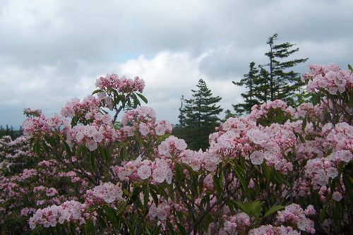
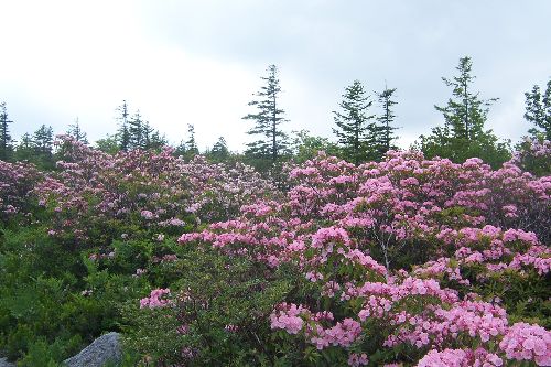
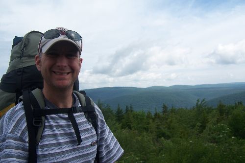
| Hike Summary: | The Roaring Plains West Wilderness is located approximately three miles southwest of the Dolly Sods Wilderness, and consists of 6,792 acres of diverse vegetation. Elevations range from approximately 2,400 feet at the trailhead parking area to 4,770 feet at the top of Mt. Porte Crayon, West Virginia's fifth highest point. The lower elevations are largely dominated by dense hardwood and spruce forests, while the higher elevations are populated by spruce and brush, with an under-story of bogs, grasses, mountain laurel, and rhododendron. This hike starts at the trailhead parking area adjacent to the bridge over Red Creek. The actual trailhead is approximately 0.2 miles back up the road, so the first little westward stint is on asphalt. At the trailhead, the Flatrock Run Trail turns south, and slowly ascends across private property for its first mile before reaching the Monongahela National Forest boundary. Hikers are allowed access here through an agreement between the Forest Service and the landowner. From the trailhead, the Flatrock Run Trail steadily climbs approximately 5.3 miles through dense forests to its junction with the Roaring Plains Trail at elevation 4,560 feet. From this junction, the Roaring Plains Trail heads mostly in an eastward direction, and after just over a quarter mile, slowly breaks out of the darkness of the forest and into the wide open skies of the plains area. This area of the plains is in stark contrast to the dimly lit forest, and is marked by a mixture of blue skies, green grasses, and thickets of laurel, rhododendron, and other brush. As the trail continues up and over the plains, it transitions into a wide open area strewn with medicine-ball-sized boulders. The Roaring Plains Trail continues to climb for a short distance to its highest point, which is just shy of 4,700 feet, and then begins its decent down to a junction with a buried pipeline right-of-way. This section of the trail alternates back and forth between multiple breathtaking stretches of impenetrable thickets of mountain laurel and wide open views of the adjacent highlands. If you go in late June, you will want to be sure to have your camera handy as the laurel will be in full bloom. Not enough can be said about the wonderfulness of the experience of walking through this portion of the trail. At the pipeline right-of-way, the hike takes a right, and then a quick left onto Forest Service Road 70. After approximately ½-mile, the hike picks back up on the Boars Nest Trail located along the left side of Forest Service Road 70. This section of the trail alternates back and forth between less impressive thickets of laurel and brush, and outcroppings of spruce. The Boars Nest Trail continues to descend to approximately 2,800 feet at its crossing of Red Creek, and then makes one last small climb to its terminus at Forest Service Road 19. To get back to the trailhead parking area, the hike heads northwest on Forest Service Road 19 for approximately one mile, takes a sharp left on County Road 45/Jenningston-Lanesville Road, continues for 1.4 miles, and then takes a sharp left followed by a sharp right to continue to follow County Road 45/1/Lanesville Road. After approximately ½-mile, the trailhead parking area will be on the right, and if you are lucky, you will be greeted by several horses. As far as campsites go, there isn’t a lot to choose from. The hillsides are steep, and the under-story is thick. The best two options appear to include a large camping area along the right hand side of the Roaring Plains Trail (when heading counterclockwise) beneath the first stand of spruce trees after exiting the plains area. There is already a fire ring here, and there are a couple nice overlooks. The second one is along the Boars Nest Trail at approximately mile 10 of the hike. This is a smaller camping area, but is again, along the right hand side of the trail (when heading counterclockwise) beneath a stand of spruce trees after exiting one of the sections of mountain laurel. This one would be easily missed if you weren’t looking for it. |


There are no comments yet.